

Recovered Route
A cycling route starting in Hailsham, England, United Kingdom.
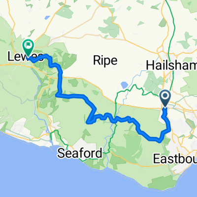
Overview
About this route
- 1 min
- Duration
- 0.2 km
- Distance
- 7 m
- Ascent
- 9 m
- Descent
- 11.1 km/h
- Avg. speed
- 27 m
- Max. altitude
Continue with Bikemap
Use, edit, or download this cycling route
You would like to ride Recovered Route or customize it for your own trip? Here is what you can do with this Bikemap route:
Free features
- Save this route as favorite or in collections
- Copy & plan your own version of this route
- Sync your route with Garmin or Wahoo
Premium features
Free trial for 3 days, or one-time payment. More about Bikemap Premium.
- Navigate this route on iOS & Android
- Export a GPX / KML file of this route
- Create your custom printout (try it for free)
- Download this route for offline navigation
Discover more Premium features.
Get Bikemap PremiumFrom our community
Other popular routes starting in Hailsham
 Beach Head 25 Miles
- Distance
- 44.3 km
- Ascent
- 695 m
- Descent
- 697 m
- Location
- Hailsham, England, United Kingdom
 92km
92km- Distance
- 91.7 km
- Ascent
- 355 m
- Descent
- 354 m
- Location
- Hailsham, England, United Kingdom
 De Elmsdown Place 5 à High Street 47
- Distance
- 35.7 km
- Ascent
- 237 m
- Descent
- 175 m
- Location
- Hailsham, England, United Kingdom
 Hailsham to Hastings
- Distance
- 32.8 km
- Ascent
- 71 m
- Descent
- 92 m
- Location
- Hailsham, England, United Kingdom
 7 sis
7 sis- Distance
- 31.7 km
- Ascent
- 664 m
- Descent
- 673 m
- Location
- Hailsham, England, United Kingdom
 Berwick to Hove
- Distance
- 40.7 km
- Ascent
- 201 m
- Descent
- 209 m
- Location
- Hailsham, England, United Kingdom
 Polegate to Lewes off road32km 690m
- Distance
- 32.1 km
- Ascent
- 731 m
- Descent
- 743 m
- Location
- Hailsham, England, United Kingdom
 newhaven-london
- Distance
- 125.1 km
- Ascent
- 1,090 m
- Descent
- 1,089 m
- Location
- Hailsham, England, United Kingdom
Open it in the app