

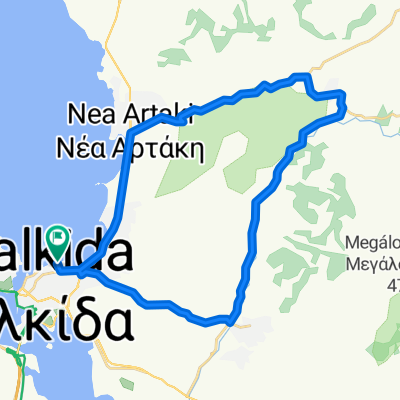
Über Paralimni, Theben und Askra nach Agia Anna
A cycling route starting in Chalcis, Central Greece, Greece.
Overview
About this route
Through Paralimni, Thebes, and Askra to Agia Anna
- -:--
- Duration
- 103.4 km
- Distance
- 808 m
- Ascent
- 705 m
- Descent
- ---
- Avg. speed
- 421 m
- Max. altitude
Route quality
Waytypes & surfaces along the route
Waytypes
Road
43.4 km
(42 %)
Quiet road
12.4 km
(12 %)
Surfaces
Paved
66.2 km
(64 %)
Unpaved
1 km
(1 %)
Asphalt
66.2 km
(64 %)
Ground
1 km
(1 %)
Undefined
36.2 km
(35 %)
Continue with Bikemap
Use, edit, or download this cycling route
You would like to ride Über Paralimni, Theben und Askra nach Agia Anna or customize it for your own trip? Here is what you can do with this Bikemap route:
Free features
- Save this route as favorite or in collections
- Copy & plan your own version of this route
- Split it into stages to create a multi-day tour
- Sync your route with Garmin or Wahoo
Premium features
Free trial for 3 days, or one-time payment. More about Bikemap Premium.
- Navigate this route on iOS & Android
- Export a GPX / KML file of this route
- Create your custom printout (try it for free)
- Download this route for offline navigation
Discover more Premium features.
Get Bikemap PremiumFrom our community
Other popular routes starting in Chalcis
 Παπαστρατή 22, Χαλκίδα to Στρατηγού Ιωάννη Λειβαρά 28, Χαλκίδα
- Distance
- 21.1 km
- Ascent
- 143 m
- Descent
- 179 m
- Location
- Chalcis, Central Greece, Greece
 Παλαιών Πατρών Γερμανού 27, Χαλκίδα to Παλαιών Πατρών Γερμανού 28, Χαλκίδα
- Distance
- 33.6 km
- Ascent
- 309 m
- Descent
- 308 m
- Location
- Chalcis, Central Greece, Greece
 Chalkideon to Λεωφόρος Εθνάρχου Μακάριου, Xirovrysi
- Distance
- 9.2 km
- Ascent
- 160 m
- Descent
- 153 m
- Location
- Chalcis, Central Greece, Greece
 02 - chalkdia stavros politika
- Distance
- 73.6 km
- Ascent
- 823 m
- Descent
- 823 m
- Location
- Chalcis, Central Greece, Greece
 Über Paralimni, Theben und Askra nach Agia Anna
- Distance
- 103.4 km
- Ascent
- 808 m
- Descent
- 705 m
- Location
- Chalcis, Central Greece, Greece
 ToG S9
- Distance
- 143.4 km
- Ascent
- 1,635 m
- Descent
- 1,607 m
- Location
- Chalcis, Central Greece, Greece
 2017_09_13_Giro del Mediterraneo - Episodio 8 - Tappa 6 - Chalkida - Nea Styra
- Distance
- 88.2 km
- Ascent
- 518 m
- Descent
- 517 m
- Location
- Chalcis, Central Greece, Greece
 Εύβοιας 64, Χαλκίδα to Agios Minas 64, Εύβοια
- Distance
- 19 km
- Ascent
- 133 m
- Descent
- 148 m
- Location
- Chalcis, Central Greece, Greece
Open it in the app