
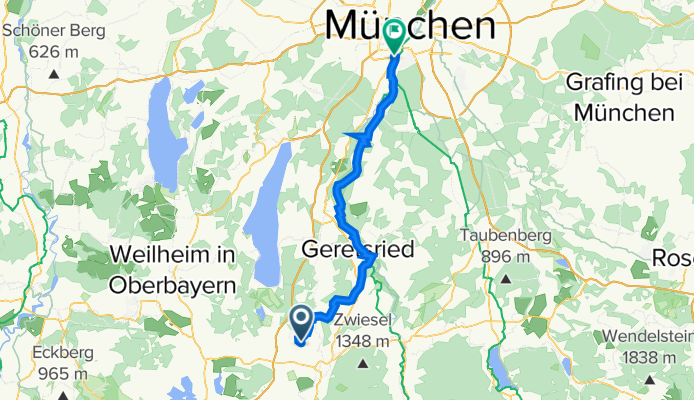
Penzberg - München
A cycling route starting in Penzberg, Bavaria, Germany.
Overview
About this route
- -:--
- Duration
- 56.4 km
- Distance
- 436 m
- Ascent
- 507 m
- Descent
- ---
- Avg. speed
- 646 m
- Max. altitude
Route quality
Waytypes & surfaces along the route
Waytypes
Quiet road
31 km
(55 %)
Track
8.5 km
(15 %)
Surfaces
Paved
38.9 km
(69 %)
Unpaved
16.9 km
(30 %)
Asphalt
38.9 km
(69 %)
Gravel
11.8 km
(21 %)
Continue with Bikemap
Use, edit, or download this cycling route
You would like to ride Penzberg - München or customize it for your own trip? Here is what you can do with this Bikemap route:
Free features
- Save this route as favorite or in collections
- Copy & plan your own version of this route
- Sync your route with Garmin or Wahoo
Premium features
Free trial for 3 days, or one-time payment. More about Bikemap Premium.
- Navigate this route on iOS & Android
- Export a GPX / KML file of this route
- Create your custom printout (try it for free)
- Download this route for offline navigation
Discover more Premium features.
Get Bikemap PremiumFrom our community
Other popular routes starting in Penzberg
 Penzberg-Antdorf-Fohnsee-Eibsee-Penzberg
- Distance
- 21 km
- Ascent
- 221 m
- Descent
- 222 m
- Location
- Penzberg, Bavaria, Germany
 Penzberg-Beuerberg
- Distance
- 63.4 km
- Ascent
- 568 m
- Descent
- 567 m
- Location
- Penzberg, Bavaria, Germany
 Rundtour Penzberg - Heilbrunn
- Distance
- 28.7 km
- Ascent
- 384 m
- Descent
- 384 m
- Location
- Penzberg, Bavaria, Germany
 720 Hm - Um Zwieselberg (1348 m) und Blomberg
- Distance
- 51.7 km
- Ascent
- 591 m
- Descent
- 593 m
- Location
- Penzberg, Bavaria, Germany
 Penzberg, Höhlmühle, Riegsee, Starnbergersee, Penzberg
- Distance
- 56.7 km
- Ascent
- 506 m
- Descent
- 503 m
- Location
- Penzberg, Bavaria, Germany
 Penzberg-Urthal-Bichl-Mürnsee-Hohenbirken-Penzberg
- Distance
- 23.5 km
- Ascent
- 154 m
- Descent
- 148 m
- Location
- Penzberg, Bavaria, Germany
 Penzberg Loisachradwegrunde
- Distance
- 20.5 km
- Ascent
- 160 m
- Descent
- 160 m
- Location
- Penzberg, Bavaria, Germany
 Penzberg-Wolfratshausen-Nantesbuch-Penzberg
- Distance
- 57.8 km
- Ascent
- 149 m
- Descent
- 149 m
- Location
- Penzberg, Bavaria, Germany
Open it in the app