

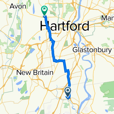
15.5 Miles
A cycling route starting in Cromwell, Connecticut, United States.
Overview
About this route
Only a few bursts on a couple of main roads that have large breakdown lane space. One small gravel section and pretty hilly sometimes on my scale. Pretty long. Sidewalk options in some parts.
- -:--
- Duration
- 25.1 km
- Distance
- 219 m
- Ascent
- 221 m
- Descent
- ---
- Avg. speed
- 70 m
- Max. altitude

Route quality
Waytypes & surfaces along the route
Waytypes
Quiet road
11.3 km
(45 %)
Road
7 km
(28 %)
Surfaces
Paved
12 km
(48 %)
Unpaved
0.3 km
(1 %)
Asphalt
12 km
(48 %)
Unpaved (undefined)
0.3 km
(1 %)
Undefined
12.8 km
(51 %)
Continue with Bikemap
Use, edit, or download this cycling route
You would like to ride 15.5 Miles or customize it for your own trip? Here is what you can do with this Bikemap route:
Free features
- Save this route as favorite or in collections
- Copy & plan your own version of this route
- Sync your route with Garmin or Wahoo
Premium features
Free trial for 3 days, or one-time payment. More about Bikemap Premium.
- Navigate this route on iOS & Android
- Export a GPX / KML file of this route
- Create your custom printout (try it for free)
- Download this route for offline navigation
Discover more Premium features.
Get Bikemap PremiumFrom our community
Other popular routes starting in Cromwell
 Deep River
- Distance
- 107.9 km
- Ascent
- 612 m
- Descent
- 630 m
- Location
- Cromwell, Connecticut, United States
 2–12 School St, Rocky Hill to 2941 Main St, Rocky Hill
- Distance
- 0.4 km
- Ascent
- 12 m
- Descent
- 0 m
- Location
- Cromwell, Connecticut, United States
 12 Miler Banger
- Distance
- 18.8 km
- Ascent
- 215 m
- Descent
- 208 m
- Location
- Cromwell, Connecticut, United States
 commute to work
- Distance
- 17.7 km
- Ascent
- ---
- Descent
- ---
- Location
- Cromwell, Connecticut, United States
 30 Berlin Rd, Cromwell to 45 Farmstead Ln, West Hartford
- Distance
- 25.8 km
- Ascent
- 180 m
- Descent
- 134 m
- Location
- Cromwell, Connecticut, United States
 Westlake to Down Town
- Distance
- 15.3 km
- Ascent
- 115 m
- Descent
- 115 m
- Location
- Cromwell, Connecticut, United States
 272 Skyview Dr, Cromwell to 45 Farmstead Ln, West Hartford
- Distance
- 25.9 km
- Ascent
- 187 m
- Descent
- 170 m
- Location
- Cromwell, Connecticut, United States
 Beach Route to Essex
- Distance
- 47.2 km
- Ascent
- 342 m
- Descent
- 381 m
- Location
- Cromwell, Connecticut, United States
Open it in the app