

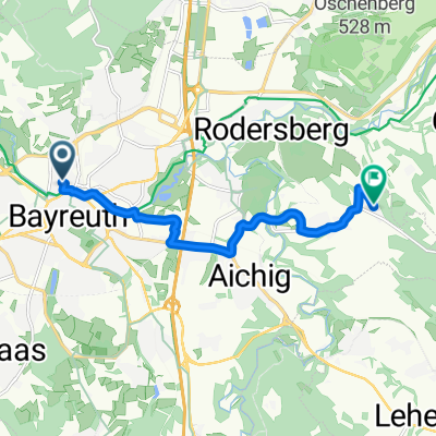
11.07.23 Bayreuth-Lichtenfels (6. Etappe)
A cycling route starting in Bayreuth, Bavaria, Germany.
Overview
About this route
From
http://www.bikemap.net/de/route/1025797-110503-ebermannstadt-bayreuth-5-etappe/
Start in Bayreuth on predominantly side roads and paths.
Connection
http://www.bikemap.net/de/route/1253822-110724-coburg-sand-am-main-7-etappe/
- -:--
- Duration
- 76.8 km
- Distance
- 248 m
- Ascent
- 334 m
- Descent
- ---
- Avg. speed
- ---
- Max. altitude

Route quality
Waytypes & surfaces along the route
Waytypes
Quiet road
23.8 km
(31 %)
Path
16.9 km
(22 %)
Surfaces
Paved
57.6 km
(75 %)
Unpaved
6.9 km
(9 %)
Asphalt
56.1 km
(73 %)
Gravel
5.4 km
(7 %)
Route highlights
Points of interest along the route
Point of interest after 73 km
Kaffeepause
Continue with Bikemap
Use, edit, or download this cycling route
You would like to ride 11.07.23 Bayreuth-Lichtenfels (6. Etappe) or customize it for your own trip? Here is what you can do with this Bikemap route:
Free features
- Save this route as favorite or in collections
- Copy & plan your own version of this route
- Sync your route with Garmin or Wahoo
Premium features
Free trial for 3 days, or one-time payment. More about Bikemap Premium.
- Navigate this route on iOS & Android
- Export a GPX / KML file of this route
- Create your custom printout (try it for free)
- Download this route for offline navigation
Discover more Premium features.
Get Bikemap PremiumFrom our community
Other popular routes starting in Bayreuth
 Route in Bayreuth
- Distance
- 8.6 km
- Ascent
- 157 m
- Descent
- 40 m
- Location
- Bayreuth, Bavaria, Germany
 11.07.23 Bayreuth-Lichtenfels (6. Etappe)
- Distance
- 76.8 km
- Ascent
- 248 m
- Descent
- 334 m
- Location
- Bayreuth, Bavaria, Germany
 Eine Anspruchsvolle aber schöne Tour
- Distance
- 30.7 km
- Ascent
- 63 m
- Descent
- 176 m
- Location
- Bayreuth, Bavaria, Germany
 Von Bayreuth bis Eger
- Distance
- 93.2 km
- Ascent
- 1,167 m
- Descent
- 1,069 m
- Location
- Bayreuth, Bavaria, Germany
 BT-Marienweiher-BT
- Distance
- 89.1 km
- Ascent
- 703 m
- Descent
- 703 m
- Location
- Bayreuth, Bavaria, Germany
 Main-Radweg – aus Trekkingbike 5/2012 - editiert 2
- Distance
- 519.1 km
- Ascent
- 167 m
- Descent
- 411 m
- Location
- Bayreuth, Bavaria, Germany
 Route im Schneckentempo in Bayreuth
- Distance
- 23.1 km
- Ascent
- 585 m
- Descent
- 547 m
- Location
- Bayreuth, Bavaria, Germany
 Rund um Bayreuth
- Distance
- 37.7 km
- Ascent
- 240 m
- Descent
- 249 m
- Location
- Bayreuth, Bavaria, Germany
Open it in the app