
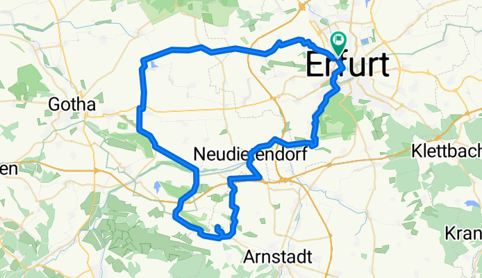
Erfurter Wesrrunde
A cycling route starting in Erfurt, Thuringia, Germany.
Overview
About this route
- -:--
- Duration
- 71.8 km
- Distance
- 371 m
- Ascent
- 374 m
- Descent
- ---
- Avg. speed
- ---
- Max. altitude

Route quality
Waytypes & surfaces along the route
Waytypes
Quiet road
23.9 km
(33 %)
Road
18.9 km
(26 %)
Surfaces
Paved
66.9 km
(93 %)
Unpaved
0.8 km
(1 %)
Asphalt
62.4 km
(87 %)
Paving stones
4.3 km
(6 %)
Continue with Bikemap
Use, edit, or download this cycling route
You would like to ride Erfurter Wesrrunde or customize it for your own trip? Here is what you can do with this Bikemap route:
Free features
- Save this route as favorite or in collections
- Copy & plan your own version of this route
- Sync your route with Garmin or Wahoo
Premium features
Free trial for 3 days, or one-time payment. More about Bikemap Premium.
- Navigate this route on iOS & Android
- Export a GPX / KML file of this route
- Create your custom printout (try it for free)
- Download this route for offline navigation
Discover more Premium features.
Get Bikemap PremiumFrom our community
Other popular routes starting in Erfurt
 3 Gleichen Runde
- Distance
- 54.4 km
- Ascent
- 254 m
- Descent
- 259 m
- Location
- Erfurt, Thuringia, Germany
 Erfurt Westlich von Erfurt mit dem Rennrad
- Distance
- 52.3 km
- Ascent
- 222 m
- Descent
- 223 m
- Location
- Erfurt, Thuringia, Germany
 Erfurt - An der Gera
- Distance
- 31.1 km
- Ascent
- 91 m
- Descent
- 91 m
- Location
- Erfurt, Thuringia, Germany
 Erfurt - Kranichfeld - Stadtilm - Ilmenau - Arnstadt - Erfurt
- Distance
- 96.1 km
- Ascent
- 506 m
- Descent
- 505 m
- Location
- Erfurt, Thuringia, Germany
 20170723_114328.gpx
- Distance
- 55.4 km
- Ascent
- 226 m
- Descent
- 227 m
- Location
- Erfurt, Thuringia, Germany
 Lutherstein Tour
- Distance
- 45.8 km
- Ascent
- 133 m
- Descent
- 143 m
- Location
- Erfurt, Thuringia, Germany
 Tour zum Riechheimer Berg
- Distance
- 43 km
- Ascent
- 628 m
- Descent
- 559 m
- Location
- Erfurt, Thuringia, Germany
 Stadtradeln 04.06.2021
- Distance
- 57.7 km
- Ascent
- 148 m
- Descent
- 148 m
- Location
- Erfurt, Thuringia, Germany
Open it in the app