

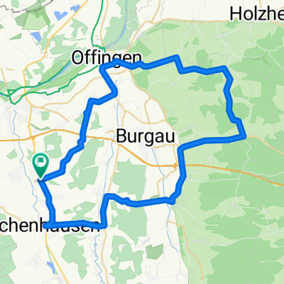
Waldkirch - Winterbach
A cycling route starting in Ichenhausen, Bavaria, Germany.
Overview
About this route
Especially in the area from Schnuttenbach to Glöttweng, a beautiful route. There, a bit hilly, but not too hard. Between Winterbach and Glöttweng, about 2 km are unpaved.
- -:--
- Duration
- 54.5 km
- Distance
- 365 m
- Ascent
- 365 m
- Descent
- ---
- Avg. speed
- ---
- Max. altitude
Route quality
Waytypes & surfaces along the route
Waytypes
Quiet road
16.9 km
(31 %)
Road
12 km
(22 %)
Surfaces
Paved
37.1 km
(68 %)
Unpaved
2.7 km
(5 %)
Asphalt
25.1 km
(46 %)
Paved (undefined)
12 km
(22 %)
Continue with Bikemap
Use, edit, or download this cycling route
You would like to ride Waldkirch - Winterbach or customize it for your own trip? Here is what you can do with this Bikemap route:
Free features
- Save this route as favorite or in collections
- Copy & plan your own version of this route
- Sync your route with Garmin or Wahoo
Premium features
Free trial for 3 days, or one-time payment. More about Bikemap Premium.
- Navigate this route on iOS & Android
- Export a GPX / KML file of this route
- Create your custom printout (try it for free)
- Download this route for offline navigation
Discover more Premium features.
Get Bikemap PremiumFrom our community
Other popular routes starting in Ichenhausen
 Wiesenbach
- Distance
- 18.6 km
- Ascent
- 68 m
- Descent
- 70 m
- Location
- Ichenhausen, Bavaria, Germany
 Breitenbrunn
- Distance
- 35.6 km
- Ascent
- 151 m
- Descent
- 82 m
- Location
- Ichenhausen, Bavaria, Germany
 Waldkirch - Winterbach
- Distance
- 54.5 km
- Ascent
- 365 m
- Descent
- 365 m
- Location
- Ichenhausen, Bavaria, Germany
 2012-08-29- an der günz
- Distance
- 24.9 km
- Ascent
- 67 m
- Descent
- 30 m
- Location
- Ichenhausen, Bavaria, Germany
 Günztal-Runde
- Distance
- 96.9 km
- Ascent
- 398 m
- Descent
- 403 m
- Location
- Ichenhausen, Bavaria, Germany
 Geislingen an der Steige - Althegnenberg
- Distance
- 158.1 km
- Ascent
- 762 m
- Descent
- 786 m
- Location
- Ichenhausen, Bavaria, Germany
 Hörlis - Halden
- Distance
- 66.8 km
- Ascent
- 314 m
- Descent
- 314 m
- Location
- Ichenhausen, Bavaria, Germany
 Heimatroute
- Distance
- 26.8 km
- Ascent
- 198 m
- Descent
- 197 m
- Location
- Ichenhausen, Bavaria, Germany
Open it in the app