
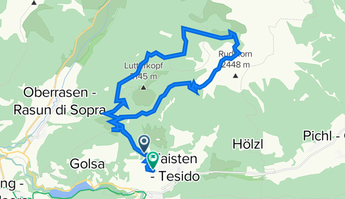
Taistner Vorderalm – Taistner Hinteralm Runde
A cycling route starting in Welsberg-Taisten, Trentino-Alto Adige, Italy.
Overview
About this route
null
- -:--
- Duration
- 21.9 km
- Distance
- 927 m
- Ascent
- 1,055 m
- Descent
- ---
- Avg. speed
- 2,187 m
- Max. altitude
Continue with Bikemap
Use, edit, or download this cycling route
You would like to ride Taistner Vorderalm – Taistner Hinteralm Runde or customize it for your own trip? Here is what you can do with this Bikemap route:
Free features
- Save this route as favorite or in collections
- Copy & plan your own version of this route
- Sync your route with Garmin or Wahoo
Premium features
Free trial for 3 days, or one-time payment. More about Bikemap Premium.
- Navigate this route on iOS & Android
- Export a GPX / KML file of this route
- Create your custom printout (try it for free)
- Download this route for offline navigation
Discover more Premium features.
Get Bikemap PremiumFrom our community
Other popular routes starting in Welsberg-Taisten
 09b--BRAIES
- Distance
- 16.9 km
- Ascent
- 383 m
- Descent
- 384 m
- Location
- Welsberg-Taisten, Trentino-Alto Adige, Italy
 20170918_MUVE_Etappe_4_Welsberg-Pieve_di_Cadore
- Distance
- 73.9 km
- Ascent
- 512 m
- Descent
- 730 m
- Location
- Welsberg-Taisten, Trentino-Alto Adige, Italy
 Welsberg Bahnhof - Thal-Aue/Assling
- Distance
- 48.4 km
- Ascent
- 181 m
- Descent
- 447 m
- Location
- Welsberg-Taisten, Trentino-Alto Adige, Italy
 Taisten - Pragser Wildsee
- Distance
- 14.9 km
- Ascent
- 460 m
- Descent
- 263 m
- Location
- Welsberg-Taisten, Trentino-Alto Adige, Italy
 Zwischen Gsieser- und Pustertal
- Distance
- 32 km
- Ascent
- 936 m
- Descent
- 938 m
- Location
- Welsberg-Taisten, Trentino-Alto Adige, Italy
 7. Etappe Welsberg Calalzo
- Distance
- 76.8 km
- Ascent
- 510 m
- Descent
- 836 m
- Location
- Welsberg-Taisten, Trentino-Alto Adige, Italy
 Cortina středa příjezd
- Distance
- 64.6 km
- Ascent
- 1,416 m
- Descent
- 1,415 m
- Location
- Welsberg-Taisten, Trentino-Alto Adige, Italy
 My Tesido Gravel Tour
- Distance
- 116 km
- Ascent
- 2,842 m
- Descent
- 2,840 m
- Location
- Welsberg-Taisten, Trentino-Alto Adige, Italy
Open it in the app