

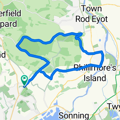
CUK Sonning Common to Chalgrove
A cycling route starting in Sonning Common, England, United Kingdom.
Overview
About this route
From Sonning Common bakery to Picnic Hamper in Chalgrove
- -:--
- Duration
- 25.9 km
- Distance
- 206 m
- Ascent
- 224 m
- Descent
- ---
- Avg. speed
- 211 m
- Max. altitude

Route quality
Waytypes & surfaces along the route
Waytypes
Road
15.8 km
(61 %)
Quiet road
9.3 km
(36 %)
Access road
0.8 km
(3 %)
Surfaces
Paved
4.4 km
(17 %)
Asphalt
4.4 km
(17 %)
Undefined
21.5 km
(83 %)
Continue with Bikemap
Use, edit, or download this cycling route
You would like to ride CUK Sonning Common to Chalgrove or customize it for your own trip? Here is what you can do with this Bikemap route:
Free features
- Save this route as favorite or in collections
- Copy & plan your own version of this route
- Sync your route with Garmin or Wahoo
Premium features
Free trial for 3 days, or one-time payment. More about Bikemap Premium.
- Navigate this route on iOS & Android
- Export a GPX / KML file of this route
- Create your custom printout (try it for free)
- Download this route for offline navigation
Discover more Premium features.
Get Bikemap PremiumFrom our community
Other popular routes starting in Sonning Common
 scouts
- Distance
- 24.7 km
- Ascent
- 211 m
- Descent
- 251 m
- Location
- Sonning Common, England, United Kingdom
 Recording from 10:10am, 4 May
- Distance
- 15.7 km
- Ascent
- 150 m
- Descent
- 149 m
- Location
- Sonning Common, England, United Kingdom
 CUK Sonning Common to Chalgrove
- Distance
- 25.9 km
- Ascent
- 206 m
- Descent
- 224 m
- Location
- Sonning Common, England, United Kingdom
 Cycle to swim at south stoke!
- Distance
- 14.4 km
- Ascent
- 112 m
- Descent
- 162 m
- Location
- Sonning Common, England, United Kingdom
 Devil's Shiplake
- Distance
- 19.3 km
- Ascent
- 172 m
- Descent
- 175 m
- Location
- Sonning Common, England, United Kingdom
 Hungerford Circular Hilly
- Distance
- 178.3 km
- Ascent
- 659 m
- Descent
- 661 m
- Location
- Sonning Common, England, United Kingdom
 Jefferson Close 9 to The Street
- Distance
- 24.2 km
- Ascent
- 206 m
- Descent
- 252 m
- Location
- Sonning Common, England, United Kingdom
 fnd
fnd- Distance
- 4.6 km
- Ascent
- 27 m
- Descent
- 29 m
- Location
- Sonning Common, England, United Kingdom
Open it in the app