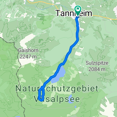
RSC TTal - Einstein
A cycling route starting in Tannheim, Tyrol, Austria.
Overview
About this route
- -:--
- Duration
- 12.4 km
- Distance
- 409 m
- Ascent
- 406 m
- Descent
- ---
- Avg. speed
- 1,477 m
- Avg. speed
Route quality
Waytypes & surfaces along the route
Waytypes
Track
7.6 km
(61 %)
Quiet road
3.3 km
(27 %)
Surfaces
Paved
4.1 km
(33 %)
Unpaved
5.5 km
(44 %)
Gravel
5.5 km
(44 %)
Asphalt
2.2 km
(18 %)
Continue with Bikemap
Use, edit, or download this cycling route
You would like to ride RSC TTal - Einstein or customize it for your own trip? Here is what you can do with this Bikemap route:
Free features
- Save this route as favorite or in collections
- Copy & plan your own version of this route
- Sync your route with Garmin or Wahoo
Premium features
Free trial for 3 days, or one-time payment. More about Bikemap Premium.
- Navigate this route on iOS & Android
- Export a GPX / KML file of this route
- Create your custom printout (try it for free)
- Download this route for offline navigation
Discover more Premium features.
Get Bikemap PremiumFrom our community
Other popular routes starting in Tannheim
- Tannheim Jungholz Tannheim
- Distance
- 40.2 km
- Ascent
- 459 m
- Descent
- 460 m
- Location
- Tannheim, Tyrol, Austria
- Tour 2013 Auf König LudwigsSpuren mittel
- Distance
- 69.8 km
- Ascent
- 666 m
- Descent
- 666 m
- Location
- Tannheim, Tyrol, Austria
- Tour 2013 Namlosrunde Schwierigkeitsgrad mittel
- Distance
- 74.5 km
- Ascent
- 947 m
- Descent
- 951 m
- Location
- Tannheim, Tyrol, Austria
- Tour Strinden Alpe
- Distance
- 23.7 km
- Ascent
- 948 m
- Descent
- 948 m
- Location
- Tannheim, Tyrol, Austria
- Vorarlbergrunde
- Distance
- 166.2 km
- Ascent
- 2,190 m
- Descent
- 2,190 m
- Location
- Tannheim, Tyrol, Austria
- Höf 1, Tannheim nach Tannheimer Straße
- Distance
- 75.5 km
- Ascent
- 1,367 m
- Descent
- 1,344 m
- Location
- Tannheim, Tyrol, Austria
- Tannheim-Nesselwaengle-Vilalbsee
- Distance
- 41.8 km
- Ascent
- 1,350 m
- Descent
- 1,350 m
- Location
- Tannheim, Tyrol, Austria
- Tannheim-Haldensee
- Distance
- 35.6 km
- Ascent
- 726 m
- Descent
- 726 m
- Location
- Tannheim, Tyrol, Austria
Open it in the app