

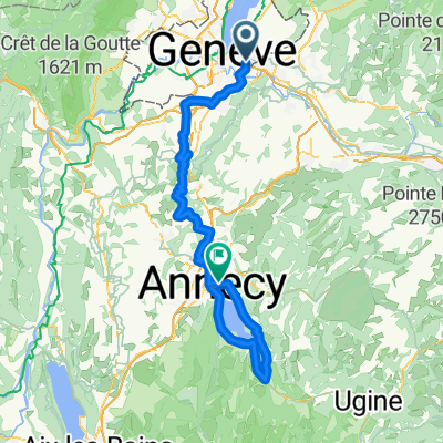
TCS TdC : parcours argent
A cycling route starting in Chêne-Bourg, Canton of Geneva, Switzerland.
Overview
About this route
- -:--
- Duration
- 92.8 km
- Distance
- 810 m
- Ascent
- 811 m
- Descent
- ---
- Avg. speed
- 519 m
- Max. altitude

Route quality
Waytypes & surfaces along the route
Waytypes
Quiet road
43.6 km
(47 %)
Road
25.1 km
(27 %)
Surfaces
Paved
66.8 km
(72 %)
Asphalt
64 km
(69 %)
Paved (undefined)
1.9 km
(2 %)
Continue with Bikemap
Use, edit, or download this cycling route
You would like to ride TCS TdC : parcours argent or customize it for your own trip? Here is what you can do with this Bikemap route:
Free features
- Save this route as favorite or in collections
- Copy & plan your own version of this route
- Split it into stages to create a multi-day tour
- Sync your route with Garmin or Wahoo
Premium features
Free trial for 3 days, or one-time payment. More about Bikemap Premium.
- Navigate this route on iOS & Android
- Export a GPX / KML file of this route
- Create your custom printout (try it for free)
- Download this route for offline navigation
Discover more Premium features.
Get Bikemap PremiumFrom our community
Other popular routes starting in Chêne-Bourg
 TCS TdC : parcours argent
- Distance
- 92.8 km
- Ascent
- 810 m
- Descent
- 811 m
- Location
- Chêne-Bourg, Canton of Geneva, Switzerland
 46.198, 6.196 a 46.372, 6.324
- Distance
- 28 km
- Ascent
- 208 m
- Descent
- 269 m
- Location
- Chêne-Bourg, Canton of Geneva, Switzerland
 TCS TdC : parcours Or
- Distance
- 132.7 km
- Ascent
- 1,114 m
- Descent
- 1,116 m
- Location
- Chêne-Bourg, Canton of Geneva, Switzerland
 Genève - Annecy (tour du lac) - Genève
- Distance
- 104.8 km
- Ascent
- 921 m
- Descent
- 880 m
- Location
- Chêne-Bourg, Canton of Geneva, Switzerland
 CB-Nonglard
- Distance
- 47.9 km
- Ascent
- 852 m
- Descent
- 738 m
- Location
- Chêne-Bourg, Canton of Geneva, Switzerland
 Tour du lac
- Distance
- 193.8 km
- Ascent
- 1,160 m
- Descent
- 1,177 m
- Location
- Chêne-Bourg, Canton of Geneva, Switzerland
 Chemin Castan 3A, Chêne-Bougeries to Rue de la Poste 3, Perroy
- Distance
- 41.6 km
- Ascent
- 214 m
- Descent
- 220 m
- Location
- Chêne-Bourg, Canton of Geneva, Switzerland
 Tour Jussy
- Distance
- 35.2 km
- Ascent
- 317 m
- Descent
- 322 m
- Location
- Chêne-Bourg, Canton of Geneva, Switzerland
Open it in the app