

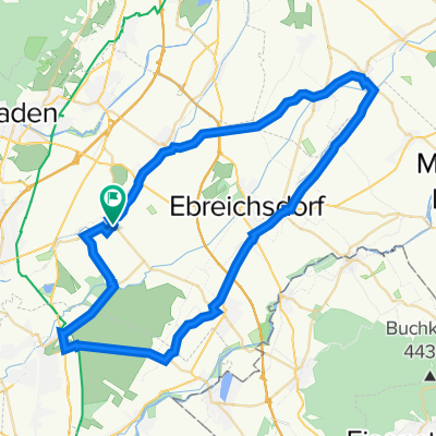
Nikolaus Dumba-Gasse 5, Tattendorf nach L4168 28
A cycling route starting in Tattendorf, Lower Austria, Austria.
Overview
About this route
- 3 h 59 min
- Duration
- 61.7 km
- Distance
- 586 m
- Ascent
- 201 m
- Descent
- 15.5 km/h
- Avg. speed
- 609 m
- Max. altitude

Route quality
Waytypes & surfaces along the route
Waytypes
Quiet road
19.1 km
(31 %)
Cycleway
17.9 km
(29 %)
Surfaces
Paved
48.8 km
(79 %)
Unpaved
1.9 km
(3 %)
Asphalt
48.2 km
(78 %)
Loose gravel
1.2 km
(2 %)
Continue with Bikemap
Use, edit, or download this cycling route
You would like to ride Nikolaus Dumba-Gasse 5, Tattendorf nach L4168 28 or customize it for your own trip? Here is what you can do with this Bikemap route:
Free features
- Save this route as favorite or in collections
- Copy & plan your own version of this route
- Sync your route with Garmin or Wahoo
Premium features
Free trial for 3 days, or one-time payment. More about Bikemap Premium.
- Navigate this route on iOS & Android
- Export a GPX / KML file of this route
- Create your custom printout (try it for free)
- Download this route for offline navigation
Discover more Premium features.
Get Bikemap PremiumFrom our community
Other popular routes starting in Tattendorf
 Weinroute
- Distance
- 45.2 km
- Ascent
- 124 m
- Descent
- 116 m
- Location
- Tattendorf, Lower Austria, Austria
 Helenental Landegg 74
- Distance
- 59 km
- Ascent
- 324 m
- Descent
- 369 m
- Location
- Tattendorf, Lower Austria, Austria
 Tattendorf
- Distance
- 87.7 km
- Ascent
- 261 m
- Descent
- 258 m
- Location
- Tattendorf, Lower Austria, Austria
 Ingenieur Julius Raab Straße 1, Tattendorf nach Johann-Böhm-Straße 13, Kottingbrunn
- Distance
- 10.6 km
- Ascent
- 46 m
- Descent
- 14 m
- Location
- Tattendorf, Lower Austria, Austria
 Testtitel :P sdflfsdjlkdsf alsdu skjfjsdf fj sdjfsdfjksdf osidjf osdjf okj osidflksj dofi sdfj oifj oiadsjfo aisjdoifj aosijf ioasjd foijasoif isajdfo iajsdfo i
- Distance
- 34.4 km
- Ascent
- 100 m
- Descent
- 74 m
- Location
- Tattendorf, Lower Austria, Austria
 RR_45km
- Distance
- 45.6 km
- Ascent
- 106 m
- Descent
- 106 m
- Location
- Tattendorf, Lower Austria, Austria
 RR_55km
- Distance
- 55.4 km
- Ascent
- 88 m
- Descent
- 88 m
- Location
- Tattendorf, Lower Austria, Austria
 Ingenieur Julius Raab Straße 1, Tattendorf nach Johann-Böhm-Straße 13, Kottingbrunn
- Distance
- 11.4 km
- Ascent
- 51 m
- Descent
- 66 m
- Location
- Tattendorf, Lower Austria, Austria
Open it in the app