
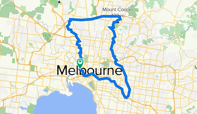
Anniversary Trail - Darebin Creek- Western Ring Road - Moonee Ponds Creek - Docklands - Yarra River- Gardiners Creek
A cycling route starting in West Melbourne, Victoria, Australia.
Overview
About this route
Distance: 81.1 kmMinimum Elevation: 13 mMaximum Elevation: 112 m
- -:--
- Duration
- 80.9 km
- Distance
- 511 m
- Ascent
- 508 m
- Descent
- ---
- Avg. speed
- 112 m
- Max. altitude

Route quality
Waytypes & surfaces along the route
Waytypes
Cycleway
75.9 km
(94 %)
Pedestrian area
2.2 km
(3 %)
Surfaces
Paved
78.9 km
(98 %)
Unpaved
0.5 km
(<1 %)
Concrete
33.9 km
(42 %)
Asphalt
33.8 km
(42 %)
Continue with Bikemap
Use, edit, or download this cycling route
You would like to ride Anniversary Trail - Darebin Creek- Western Ring Road - Moonee Ponds Creek - Docklands - Yarra River- Gardiners Creek or customize it for your own trip? Here is what you can do with this Bikemap route:
Free features
- Save this route as favorite or in collections
- Copy & plan your own version of this route
- Split it into stages to create a multi-day tour
- Sync your route with Garmin or Wahoo
Premium features
Free trial for 3 days, or one-time payment. More about Bikemap Premium.
- Navigate this route on iOS & Android
- Export a GPX / KML file of this route
- Create your custom printout (try it for free)
- Download this route for offline navigation
Discover more Premium features.
Get Bikemap PremiumFrom our community
Other popular routes starting in West Melbourne
 Slow ride in Melbourne
- Distance
- 32.3 km
- Ascent
- 395 m
- Descent
- 384 m
- Location
- West Melbourne, Victoria, Australia
 Rapha women Thursday ride
- Distance
- 17.3 km
- Ascent
- 285 m
- Descent
- 266 m
- Location
- West Melbourne, Victoria, Australia
 Lengthy ride from West Melbourne to Docklands
- Distance
- 30.8 km
- Ascent
- 80 m
- Descent
- 88 m
- Location
- West Melbourne, Victoria, Australia
 Home to FHS
- Distance
- 5.6 km
- Ascent
- 39 m
- Descent
- 38 m
- Location
- West Melbourne, Victoria, Australia
 City to Flemington
- Distance
- 3 km
- Ascent
- 22 m
- Descent
- 40 m
- Location
- West Melbourne, Victoria, Australia
 Spencer Street 479-485, West Melbourne to Rosslyn Street 162, West Melbourne
- Distance
- 30.1 km
- Ascent
- 81 m
- Descent
- 102 m
- Location
- West Melbourne, Victoria, Australia
 Anniversary Trail - Darebin Creek- Western Ring Road - Moonee Ponds Creek - Docklands - Yarra River- Gardiners Creek
- Distance
- 80.9 km
- Ascent
- 511 m
- Descent
- 508 m
- Location
- West Melbourne, Victoria, Australia
 alt capital track
- Distance
- 15.1 km
- Ascent
- 91 m
- Descent
- 84 m
- Location
- West Melbourne, Victoria, Australia
Open it in the app