

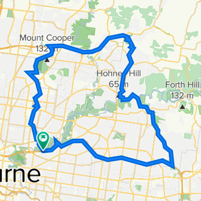
Koonung Creek(EastLink) - Mullum Mullum Creek - Yarra River- Diamond Creek - Western/Metropolitan Ring Road - Darebin Creek - Yarra River.
A cycling route starting in Ivanhoe East, Victoria, Australia.
Overview
About this route
Distance: 67.8 kmMinimum Elevation: 16 mMaximum Elevation: 134 m
- -:--
- Duration
- 68.8 km
- Distance
- 505 m
- Ascent
- 504 m
- Descent
- ---
- Avg. speed
- 134 m
- Max. altitude

Route quality
Waytypes & surfaces along the route
Waytypes
Cycleway
57.1 km
(83 %)
Quiet road
4.1 km
(6 %)
Surfaces
Paved
59.9 km
(87 %)
Unpaved
4.1 km
(6 %)
Asphalt
28.9 km
(42 %)
Concrete
22.7 km
(33 %)
Continue with Bikemap
Use, edit, or download this cycling route
You would like to ride Koonung Creek(EastLink) - Mullum Mullum Creek - Yarra River- Diamond Creek - Western/Metropolitan Ring Road - Darebin Creek - Yarra River. or customize it for your own trip? Here is what you can do with this Bikemap route:
Free features
- Save this route as favorite or in collections
- Copy & plan your own version of this route
- Sync your route with Garmin or Wahoo
Premium features
Free trial for 3 days, or one-time payment. More about Bikemap Premium.
- Navigate this route on iOS & Android
- Export a GPX / KML file of this route
- Create your custom printout (try it for free)
- Download this route for offline navigation
Discover more Premium features.
Get Bikemap PremiumFrom our community
Other popular routes starting in Ivanhoe East
 Blistering ride in Southbank
- Distance
- 19.6 km
- Ascent
- 160 m
- Descent
- 175 m
- Location
- Ivanhoe East, Victoria, Australia
 Easy ride in Fairfield
- Distance
- 5 km
- Ascent
- 140 m
- Descent
- 127 m
- Location
- Ivanhoe East, Victoria, Australia
 Quick ride through Ivanhoe East
- Distance
- 4.7 km
- Ascent
- 54 m
- Descent
- 56 m
- Location
- Ivanhoe East, Victoria, Australia
 Eastlink North InB
- Distance
- 34.9 km
- Ascent
- 203 m
- Descent
- 167 m
- Location
- Ivanhoe East, Victoria, Australia
 Ttyt
Ttyt- Distance
- 8.2 km
- Ascent
- 112 m
- Descent
- 112 m
- Location
- Ivanhoe East, Victoria, Australia
 Brief bike tour through Ivanhoe East
- Distance
- 4.8 km
- Ascent
- 53 m
- Descent
- 53 m
- Location
- Ivanhoe East, Victoria, Australia
 Koonung Creek(EastLink) - Mullum Mullum Creek - Yarra River- Diamond Creek - Western/Metropolitan Ring Road - Darebin Creek - Yarra River.
- Distance
- 68.8 km
- Ascent
- 505 m
- Descent
- 504 m
- Location
- Ivanhoe East, Victoria, Australia
 Home Stretch
- Distance
- 10.3 km
- Ascent
- 111 m
- Descent
- 110 m
- Location
- Ivanhoe East, Victoria, Australia
Open it in the app