

2022 Tour1 final
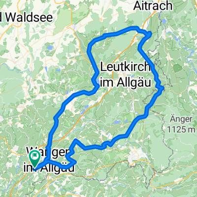
A cycling route starting in Wangen, Baden-Wurttemberg, Germany.
Overview
About this route
- -:--
- Duration
- 156 km
- Distance
- 1,738 m
- Ascent
- 1,722 m
- Descent
- ---
- Avg. speed
- 748 m
- Max. altitude
Route quality
Waytypes & surfaces along the route
Waytypes
Road
68.9 km
(44 %)
Quiet road
56.8 km
(36 %)
Surfaces
Paved
93.4 km
(60 %)
Unpaved
0.1 km
(<1 %)
Asphalt
92.1 km
(59 %)
Paved (undefined)
1.1 km
(<1 %)
Continue with Bikemap
Use, edit, or download this cycling route
You would like to ride 2022 Tour1 final or customize it for your own trip? Here is what you can do with this Bikemap route:
Free features
- Save this route as favorite or in collections
- Copy & plan your own version of this route
- Split it into stages to create a multi-day tour
- Sync your route with Garmin or Wahoo
Premium features
Free trial for 3 days, or one-time payment. More about Bikemap Premium.
- Navigate this route on iOS & Android
- Export a GPX / KML file of this route
- Create your custom printout (try it for free)
- Download this route for offline navigation
Discover more Premium features.
Get Bikemap PremiumFrom our community
Other popular routes starting in Wangen
 Mountainbiketour 2014
- Distance
- 41 km
- Ascent
- 268 m
- Descent
- 274 m
- Location
- Wangen, Baden-Wurttemberg, Germany
 Missener Hausrunde
- Distance
- 18.5 km
- Ascent
- 287 m
- Descent
- 295 m
- Location
- Wangen, Baden-Wurttemberg, Germany
 Wangen - Geiselharz - Kißlegg - Wangen
- Distance
- 40.7 km
- Ascent
- 530 m
- Descent
- 527 m
- Location
- Wangen, Baden-Wurttemberg, Germany
 Allgäu Rundfahrt eines bekannten MTB Sportvereins...
- Distance
- 47.7 km
- Ascent
- 653 m
- Descent
- 651 m
- Location
- Wangen, Baden-Wurttemberg, Germany
 Runde auf ruhigen Straßen
- Distance
- 22.8 km
- Ascent
- 151 m
- Descent
- 151 m
- Location
- Wangen, Baden-Wurttemberg, Germany
 Deutsche Strassenmeisterschaft 2013 Frauen / Elite Männer
- Distance
- 42.2 km
- Ascent
- 415 m
- Descent
- 415 m
- Location
- Wangen, Baden-Wurttemberg, Germany
 2025 Tour 2 Barockstr. 16.06.25
- Distance
- 99.6 km
- Ascent
- 1,199 m
- Descent
- 1,198 m
- Location
- Wangen, Baden-Wurttemberg, Germany
 MTB Allgäu Rundfahrt
- Distance
- 47 km
- Ascent
- 704 m
- Descent
- 702 m
- Location
- Wangen, Baden-Wurttemberg, Germany
Open it in the app