

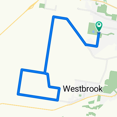
Highfields to Oakey to Westbrook
A cycling route starting in Wilsonton Heights, Queensland, Australia.
Overview
About this route
- -:--
- Duration
- 58.7 km
- Distance
- 240 m
- Ascent
- 384 m
- Descent
- ---
- Avg. speed
- ---
- Max. altitude
Route quality
Waytypes & surfaces along the route
Waytypes
Road
27.6 km
(47 %)
Quiet road
16.4 km
(28 %)
Surfaces
Paved
55.2 km
(94 %)
Unpaved
1.8 km
(3 %)
Paved (undefined)
39.3 km
(67 %)
Asphalt
13.5 km
(23 %)
Continue with Bikemap
Use, edit, or download this cycling route
You would like to ride Highfields to Oakey to Westbrook or customize it for your own trip? Here is what you can do with this Bikemap route:
Free features
- Save this route as favorite or in collections
- Copy & plan your own version of this route
- Sync your route with Garmin or Wahoo
Premium features
Free trial for 3 days, or one-time payment. More about Bikemap Premium.
- Navigate this route on iOS & Android
- Export a GPX / KML file of this route
- Create your custom printout (try it for free)
- Download this route for offline navigation
Discover more Premium features.
Get Bikemap PremiumFrom our community
Other popular routes starting in Wilsonton Heights
 Kleinton - Meringandan - Highfields
- Distance
- 17.9 km
- Ascent
- 264 m
- Descent
- 263 m
- Location
- Wilsonton Heights, Queensland, Australia
 Highfields (Queensland) East Path Loop
- Distance
- 8.7 km
- Ascent
- 36 m
- Descent
- 34 m
- Location
- Wilsonton Heights, Queensland, Australia
 Collingwood descent
- Distance
- 35.1 km
- Ascent
- 298 m
- Descent
- 694 m
- Location
- Wilsonton Heights, Queensland, Australia
 TT ENDEAVOUR 30KM
- Distance
- 28 km
- Ascent
- 241 m
- Descent
- 241 m
- Location
- Wilsonton Heights, Queensland, Australia
 morning loop
- Distance
- 18.7 km
- Ascent
- 159 m
- Descent
- 160 m
- Location
- Wilsonton Heights, Queensland, Australia
 kingsthorpe gorrie highfields
- Distance
- 44.9 km
- Ascent
- 620 m
- Descent
- 620 m
- Location
- Wilsonton Heights, Queensland, Australia
 Snail-like route in Newtown
- Distance
- 2.3 km
- Ascent
- 0 m
- Descent
- 56 m
- Location
- Wilsonton Heights, Queensland, Australia
 87 Holberton Street, Newtown to 40 Wirra Wirra Street, East Toowoomba
- Distance
- 6.5 km
- Ascent
- 126 m
- Descent
- 61 m
- Location
- Wilsonton Heights, Queensland, Australia
Open it in the app