
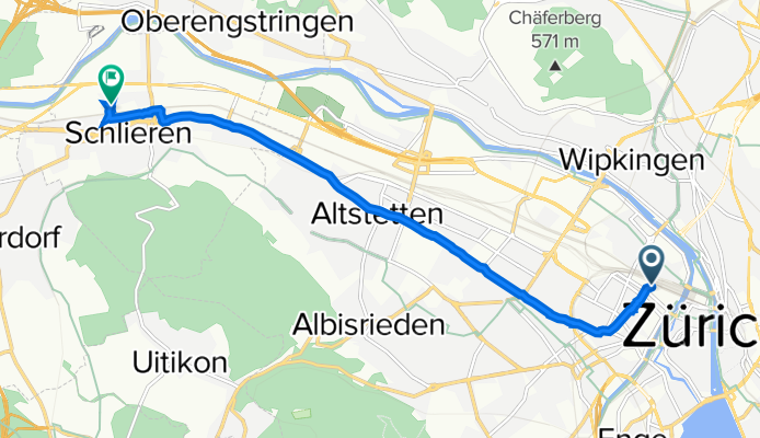
Gustav-Gull-Platz 11, Zurich to Wiesenstrasse 16, Schlieren
A cycling route starting in Zürich (Kreis 4) / Langstrasse, Canton of Zurich, Switzerland.
Overview
About this route
- 25 min
- Duration
- 8.4 km
- Distance
- 71 m
- Ascent
- 91 m
- Descent
- 20.1 km/h
- Avg. speed
- 432 m
- Max. altitude
Route quality
Waytypes & surfaces along the route
Waytypes
Pedestrian area
2.4 km
(28 %)
Road
2.1 km
(25 %)
Surfaces
Paved
8 km
(95 %)
Asphalt
8 km
(95 %)
Paved (undefined)
0 km
(<1 %)
Undefined
0.4 km
(5 %)
Continue with Bikemap
Use, edit, or download this cycling route
You would like to ride Gustav-Gull-Platz 11, Zurich to Wiesenstrasse 16, Schlieren or customize it for your own trip? Here is what you can do with this Bikemap route:
Free features
- Save this route as favorite or in collections
- Copy & plan your own version of this route
- Sync your route with Garmin or Wahoo
Premium features
Free trial for 3 days, or one-time payment. More about Bikemap Premium.
- Navigate this route on iOS & Android
- Export a GPX / KML file of this route
- Create your custom printout (try it for free)
- Download this route for offline navigation
Discover more Premium features.
Get Bikemap PremiumFrom our community
Other popular routes starting in Zürich (Kreis 4) / Langstrasse
 96KM Zürich
- Distance
- 95.8 km
- Ascent
- 935 m
- Descent
- 937 m
- Location
- Zürich (Kreis 4) / Langstrasse, Canton of Zurich, Switzerland
 Zürisee einfach
- Distance
- 77.1 km
- Ascent
- 118 m
- Descent
- 119 m
- Location
- Zürich (Kreis 4) / Langstrasse, Canton of Zurich, Switzerland
 Sihl-Limmat-Brugg-Reuss-Albis
- Distance
- 103.9 km
- Ascent
- 1,130 m
- Descent
- 1,129 m
- Location
- Zürich (Kreis 4) / Langstrasse, Canton of Zurich, Switzerland
 Lägern, Altberg
- Distance
- 59.2 km
- Ascent
- 1,010 m
- Descent
- 1,013 m
- Location
- Zürich (Kreis 4) / Langstrasse, Canton of Zurich, Switzerland
 Green Halbmarathon by OSP
- Distance
- 19.4 km
- Ascent
- 165 m
- Descent
- 572 m
- Location
- Zürich (Kreis 4) / Langstrasse, Canton of Zurich, Switzerland
 Bicycle Touring Trip - 2010
- Distance
- 1,096.9 km
- Ascent
- 3,809 m
- Descent
- 3,807 m
- Location
- Zürich (Kreis 4) / Langstrasse, Canton of Zurich, Switzerland
 Albiskette
- Distance
- 54.7 km
- Ascent
- 787 m
- Descent
- 787 m
- Location
- Zürich (Kreis 4) / Langstrasse, Canton of Zurich, Switzerland
 Big Roundtrip Zurichsee//Obersee
- Distance
- 68.7 km
- Ascent
- 48 m
- Descent
- 48 m
- Location
- Zürich (Kreis 4) / Langstrasse, Canton of Zurich, Switzerland
Open it in the app