

way back
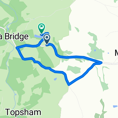
A cycling route starting in South Brent, England, United Kingdom.
Overview
About this route
- 36 min
- Duration
- 13.8 km
- Distance
- 182 m
- Ascent
- 303 m
- Descent
- 23.1 km/h
- Avg. speed
- 146 m
- Max. altitude

Route quality
Waytypes & surfaces along the route
Waytypes
Road
9.3 km
(67 %)
Quiet road
2.5 km
(18 %)
Surfaces
Paved
12.2 km
(88 %)
Unpaved
0.3 km
(2 %)
Asphalt
12.2 km
(88 %)
Gravel
0.3 km
(2 %)
Undefined
1.4 km
(10 %)
Continue with Bikemap
Use, edit, or download this cycling route
You would like to ride way back or customize it for your own trip? Here is what you can do with this Bikemap route:
Free features
- Save this route as favorite or in collections
- Copy & plan your own version of this route
- Sync your route with Garmin or Wahoo
Premium features
Free trial for 3 days, or one-time payment. More about Bikemap Premium.
- Navigate this route on iOS & Android
- Export a GPX / KML file of this route
- Create your custom printout (try it for free)
- Download this route for offline navigation
Discover more Premium features.
Get Bikemap PremiumFrom our community
Other popular routes starting in South Brent
 Avonwick 2 Bovey T
- Distance
- 37.3 km
- Ascent
- 545 m
- Descent
- 631 m
- Location
- South Brent, England, United Kingdom
 morleigh loop
- Distance
- 6.4 km
- Ascent
- 156 m
- Descent
- 186 m
- Location
- South Brent, England, United Kingdom
 Quillcot, South Brent to Quillcot, South Brent
- Distance
- 3 km
- Ascent
- 89 m
- Descent
- 88 m
- Location
- South Brent, England, United Kingdom
 Sharpham via Totnes
- Distance
- 23.4 km
- Ascent
- 527 m
- Descent
- 544 m
- Location
- South Brent, England, United Kingdom
 Rattery campsite
- Distance
- 18.2 km
- Ascent
- 1,693 m
- Descent
- 1,755 m
- Location
- South Brent, England, United Kingdom
 Totnes - Briz
- Distance
- 190 km
- Ascent
- 1,194 m
- Descent
- 1,262 m
- Location
- South Brent, England, United Kingdom
 dam back to Totnes
- Distance
- 20.5 km
- Ascent
- 170 m
- Descent
- 499 m
- Location
- South Brent, England, United Kingdom
 Relaxed route in United Kingdom
- Distance
- 17.4 km
- Ascent
- 692 m
- Descent
- 695 m
- Location
- South Brent, England, United Kingdom
Open it in the app