

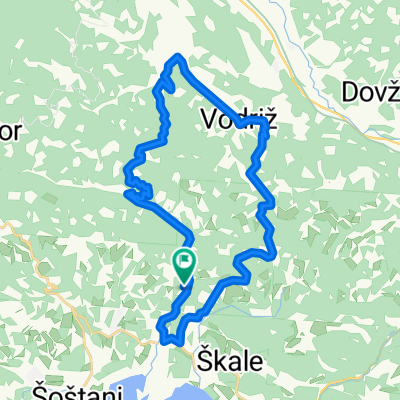
The heart of Veleje
A cycling route starting in Ravne, Občina Šoštanj, Slovenia.
Overview
About this route
- 5 h 4 min
- Duration
- 63 km
- Distance
- 805 m
- Ascent
- 799 m
- Descent
- 12.4 km/h
- Avg. speed
- 522 m
- Max. altitude

Continue with Bikemap
Use, edit, or download this cycling route
You would like to ride The heart of Veleje or customize it for your own trip? Here is what you can do with this Bikemap route:
Free features
- Save this route as favorite or in collections
- Copy & plan your own version of this route
- Sync your route with Garmin or Wahoo
Premium features
Free trial for 3 days, or one-time payment. More about Bikemap Premium.
- Navigate this route on iOS & Android
- Export a GPX / KML file of this route
- Create your custom printout (try it for free)
- Download this route for offline navigation
Discover more Premium features.
Get Bikemap PremiumFrom our community
Other popular routes starting in Ravne
 Velunja-Graška Gora-Podgorje-Velunja
- Distance
- 29.4 km
- Ascent
- 723 m
- Descent
- 722 m
- Location
- Ravne, Občina Šoštanj, Slovenia
 Velunja-graška gora-Vrhe-Podgorje-Velunja
- Distance
- 42.4 km
- Ascent
- 890 m
- Descent
- 892 m
- Location
- Ravne, Občina Šoštanj, Slovenia
 Dom _ Zavrse
- Distance
- 34.3 km
- Ascent
- 709 m
- Descent
- 947 m
- Location
- Ravne, Občina Šoštanj, Slovenia
 Recording from 29 May 2017, 20:13
- Distance
- 112 km
- Ascent
- 3,032 m
- Descent
- 3,031 m
- Location
- Ravne, Občina Šoštanj, Slovenia
 Golte-Graška Gora
- Distance
- 78.7 km
- Ascent
- 1,593 m
- Descent
- 1,593 m
- Location
- Ravne, Občina Šoštanj, Slovenia
 Vodeno doživetje, POT 1 – Na Goro jurišev
- Distance
- 26.6 km
- Ascent
- 793 m
- Descent
- 793 m
- Location
- Ravne, Občina Šoštanj, Slovenia
 Vernerica
- Distance
- 42.9 km
- Ascent
- 1,130 m
- Descent
- 1,130 m
- Location
- Ravne, Občina Šoštanj, Slovenia
 The heart of Veleje
- Distance
- 63 km
- Ascent
- 805 m
- Descent
- 799 m
- Location
- Ravne, Občina Šoštanj, Slovenia
Open it in the app