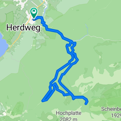
Buching Kenzenhütte
A cycling route starting in Halblech, Bavaria, Germany.
Overview
About this route
Â
- -:--
- Duration
- 24.1 km
- Distance
- 927 m
- Ascent
- 768 m
- Descent
- ---
- Avg. speed
- 1,349 m
- Avg. speed
Route quality
Waytypes & surfaces along the route
Waytypes
Track
23.3 km
(96 %)
Quiet road
0.7 km
(3 %)
Path
0.2 km
(<1 %)
Surfaces
Paved
12.4 km
(52 %)
Unpaved
11.7 km
(48 %)
Asphalt
12.4 km
(52 %)
Gravel
5.4 km
(22 %)
Continue with Bikemap
Use, edit, or download this cycling route
You would like to ride Buching Kenzenhütte or customize it for your own trip? Here is what you can do with this Bikemap route:
Free features
- Save this route as favorite or in collections
- Copy & plan your own version of this route
- Sync your route with Garmin or Wahoo
Premium features
Free trial for 3 days, or one-time payment. More about Bikemap Premium.
- Navigate this route on iOS & Android
- Export a GPX / KML file of this route
- Create your custom printout (try it for free)
- Download this route for offline navigation
Discover more Premium features.
Get Bikemap PremiumFrom our community
Other popular routes starting in Halblech
- Hallblech, Wieskirche um den hohen Traufberg
- Distance
- 42.5 km
- Ascent
- 565 m
- Descent
- 566 m
- Location
- Halblech, Bavaria, Germany
- Kenzenhütte
- Distance
- 24.5 km
- Ascent
- 744 m
- Descent
- 744 m
- Location
- Halblech, Bavaria, Germany
- Von Halblech um den Hohen Trauchberg CLONED FROM ROUTE 34572
- Distance
- 36.6 km
- Ascent
- 826 m
- Descent
- 773 m
- Location
- Halblech, Bavaria, Germany
- Wolfskopf
- Distance
- 24.3 km
- Ascent
- 890 m
- Descent
- 894 m
- Location
- Halblech, Bavaria, Germany
- Roethenbachtal-Traúchberg
- Distance
- 67.3 km
- Ascent
- 2,412 m
- Descent
- 1,871 m
- Location
- Halblech, Bavaria, Germany
- Buching Kenzenhütte
- Distance
- 24.1 km
- Ascent
- 927 m
- Descent
- 768 m
- Location
- Halblech, Bavaria, Germany
- Buching Kenzenhütte
- Distance
- 24.2 km
- Ascent
- 631 m
- Descent
- 637 m
- Location
- Halblech, Bavaria, Germany
- Oberammergau
- Distance
- 102.6 km
- Ascent
- 538 m
- Descent
- 538 m
- Location
- Halblech, Bavaria, Germany
Open it in the app