

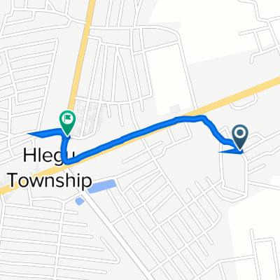
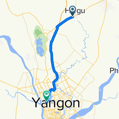
Yangon - Mandalay Highway, Hlegu to Hlegu-Phaunggyi Road
A cycling route starting in Thanatpin, Bago Region, Myanmar [Burma].
Overview
About this route
- 8 min
- Duration
- 1.2 km
- Distance
- 17 m
- Ascent
- 12 m
- Descent
- 8.8 km/h
- Avg. speed
- 19 m
- Avg. speed

Continue with Bikemap
Use, edit, or download this cycling route
You would like to ride Yangon - Mandalay Highway, Hlegu to Hlegu-Phaunggyi Road or customize it for your own trip? Here is what you can do with this Bikemap route:
Free features
- Save this route as favorite or in collections
- Copy & plan your own version of this route
- Sync your route with Garmin or Wahoo
Premium features
Free trial for 3 days, or one-time payment. More about Bikemap Premium.
- Navigate this route on iOS & Android
- Export a GPX / KML file of this route
- Create your custom printout (try it for free)
- Download this route for offline navigation
Discover more Premium features.
Get Bikemap PremiumFrom our community
Other popular routes starting in Thanatpin
 Yangon - Mandalay Highway, Hlegu to Hlegu-Phaunggyi Road
- Distance
- 1.2 km
- Ascent
- 17 m
- Descent
- 12 m
- Location
- Thanatpin, Bago Region, Myanmar [Burma]
 kk hlegu
- Distance
- 3.2 km
- Ascent
- 0 m
- Descent
- 4 m
- Location
- Thanatpin, Bago Region, Myanmar [Burma]
 No: 1 Yangon - Mandalay Hwy, Helgu to San Yeik Nyein 3rd Street, Kamayut Township
- Distance
- 36.9 km
- Ascent
- 464 m
- Descent
- 460 m
- Location
- Thanatpin, Bago Region, Myanmar [Burma]
 Hlegu Tar Sone (Bago Rd) to Yangon - Mandalay Highway, Hlegu
- Distance
- 0.9 km
- Ascent
- 62 m
- Descent
- 9 m
- Location
- Thanatpin, Bago Region, Myanmar [Burma]
Open it in the app