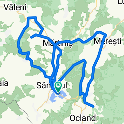
Biciklitura Magyarorszag
A cycling route starting in Ocland, Harghita County, Romania.
Overview
About this route
aug 15-20 2022
- -:--
- Duration
- 643.9 km
- Distance
- 2,945 m
- Ascent
- 3,308 m
- Descent
- ---
- Avg. speed
- 637 m
- Max. altitude
Route quality
Waytypes & surfaces along the route
Waytypes
Busy road
318.3 km
(49 %)
Quiet road
121 km
(19 %)
Surfaces
Paved
455.8 km
(71 %)
Unpaved
53.7 km
(8 %)
Asphalt
441.1 km
(68 %)
Gravel
31.7 km
(5 %)
Continue with Bikemap
Use, edit, or download this cycling route
You would like to ride Biciklitura Magyarorszag or customize it for your own trip? Here is what you can do with this Bikemap route:
Free features
- Save this route as favorite or in collections
- Copy & plan your own version of this route
- Split it into stages to create a multi-day tour
- Sync your route with Garmin or Wahoo
Premium features
Free trial for 3 days, or one-time payment. More about Bikemap Premium.
- Navigate this route on iOS & Android
- Export a GPX / KML file of this route
- Create your custom printout (try it for free)
- Download this route for offline navigation
Discover more Premium features.
Get Bikemap PremiumFrom our community
Other popular routes starting in Ocland
- Sátorfa biciklis zarándoklat 2016 - szombat
- Distance
- 51.4 km
- Ascent
- 1,005 m
- Descent
- 342 m
- Location
- Ocland, Harghita County, Romania
- Persányi capricio
- Distance
- 33.8 km
- Ascent
- 1,159 m
- Descent
- 1,149 m
- Location
- Ocland, Harghita County, Romania
- Ocland Miercurea Ciuc Ocland 86/1100
- Distance
- 95.2 km
- Ascent
- 872 m
- Descent
- 871 m
- Location
- Ocland, Harghita County, Romania
- 2018_BnR_D4_short: Petreni - Talisoara
- Distance
- 26.4 km
- Ascent
- 291 m
- Descent
- 286 m
- Location
- Ocland, Harghita County, Romania
- Biciklitura Magyarorszag
- Distance
- 643.9 km
- Ascent
- 2,945 m
- Descent
- 3,308 m
- Location
- Ocland, Harghita County, Romania
- kincsk.2020.nagytav 1.3
- Distance
- 59.9 km
- Ascent
- 908 m
- Descent
- 908 m
- Location
- Ocland, Harghita County, Romania
- torolni
- Distance
- 3.3 km
- Ascent
- 17 m
- Descent
- 183 m
- Location
- Ocland, Harghita County, Romania
- Cheile Varghisului
- Distance
- 45.9 km
- Ascent
- 535 m
- Descent
- 531 m
- Location
- Ocland, Harghita County, Romania
Open it in the app