
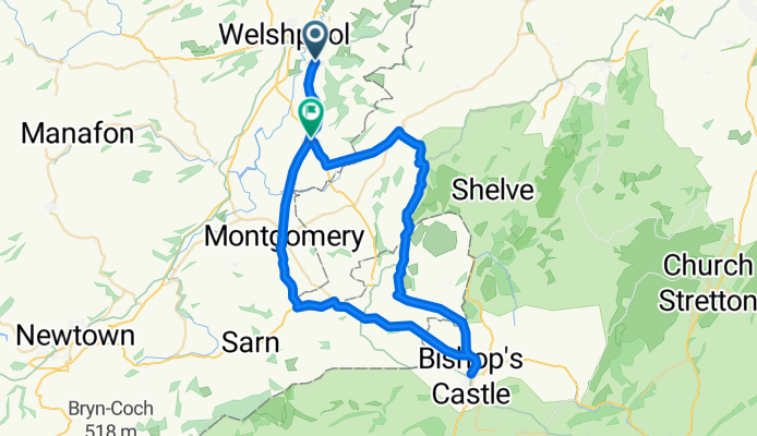
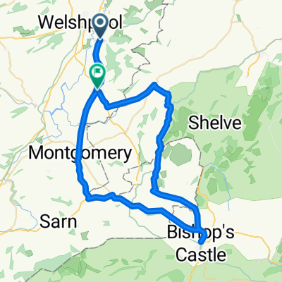
Leighton to Churchstoke
A cycling route starting in Welshpool, Wales, United Kingdom.
Overview
About this route
- -:--
- Duration
- 50.6 km
- Distance
- 513 m
- Ascent
- 465 m
- Descent
- ---
- Avg. speed
- ---
- Max. altitude
Route quality
Waytypes & surfaces along the route
Waytypes
Quiet road
18.2 km
(36 %)
Road
3.5 km
(7 %)
Surfaces
Paved
37.5 km
(74 %)
Asphalt
37.5 km
(74 %)
Undefined
13.2 km
(26 %)
Continue with Bikemap
Use, edit, or download this cycling route
You would like to ride Leighton to Churchstoke or customize it for your own trip? Here is what you can do with this Bikemap route:
Free features
- Save this route as favorite or in collections
- Copy & plan your own version of this route
- Sync your route with Garmin or Wahoo
Premium features
Free trial for 3 days, or one-time payment. More about Bikemap Premium.
- Navigate this route on iOS & Android
- Export a GPX / KML file of this route
- Create your custom printout (try it for free)
- Download this route for offline navigation
Discover more Premium features.
Get Bikemap PremiumFrom our community
Other popular routes starting in Welshpool
 first welsh ride
- Distance
- 138 km
- Ascent
- 1,661 m
- Descent
- 1,662 m
- Location
- Welshpool, Wales, United Kingdom
 Canalside, Welshpool to Welshpool Community, Welshpool
- Distance
- 0.9 km
- Ascent
- 4 m
- Descent
- 4 m
- Location
- Welshpool, Wales, United Kingdom
 Recovered Route
- Distance
- 23.3 km
- Ascent
- 882 m
- Descent
- 854 m
- Location
- Welshpool, Wales, United Kingdom
 Leighton to Churchstoke
- Distance
- 50.6 km
- Ascent
- 513 m
- Descent
- 465 m
- Location
- Welshpool, Wales, United Kingdom
 LC to Brecon
- Distance
- 105.1 km
- Ascent
- 1,106 m
- Descent
- 1,220 m
- Location
- Welshpool, Wales, United Kingdom
 Welshpool to Machynlleth
- Distance
- 71.9 km
- Ascent
- 841 m
- Descent
- 907 m
- Location
- Welshpool, Wales, United Kingdom
 Leighton->Bishops Castle via Montgomery->back via Powys castle
- Distance
- 59.1 km
- Ascent
- 444 m
- Descent
- 444 m
- Location
- Welshpool, Wales, United Kingdom
 Recovered Route
- Distance
- 4.8 km
- Ascent
- 149 m
- Descent
- 149 m
- Location
- Welshpool, Wales, United Kingdom
Open it in the app