

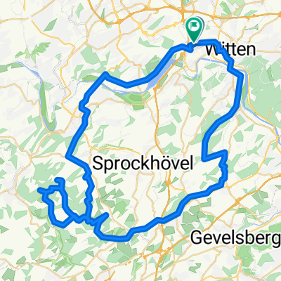
Tour 44.5km Witten Hbf. - Mettmann Jubi*
A cycling route starting in Witten, North Rhine-Westphalia, Germany.
Overview
About this route
Radwandern mit dem RV Edelweiss Mettmann 1906
Radwandertour : 18 September 2022
Tourverlauf : Witten Hbf. - Mettmann Jubi *
Distanz a ca. 45km, Profil wellig, mit Rast und Pausen.
mit sportlichen Gruß, euer Horst
- -:--
- Duration
- 44.5 km
- Distance
- 465 m
- Ascent
- 436 m
- Descent
- ---
- Avg. speed
- 266 m
- Max. altitude

Route quality
Waytypes & surfaces along the route
Waytypes
Path
18.3 km
(41 %)
Quiet road
4.9 km
(11 %)
Surfaces
Paved
41.4 km
(93 %)
Asphalt
40.1 km
(90 %)
Concrete
1.3 km
(3 %)
Undefined
3.1 km
(7 %)
Continue with Bikemap
Use, edit, or download this cycling route
You would like to ride Tour 44.5km Witten Hbf. - Mettmann Jubi* or customize it for your own trip? Here is what you can do with this Bikemap route:
Free features
- Save this route as favorite or in collections
- Copy & plan your own version of this route
- Sync your route with Garmin or Wahoo
Premium features
Free trial for 3 days, or one-time payment. More about Bikemap Premium.
- Navigate this route on iOS & Android
- Export a GPX / KML file of this route
- Create your custom printout (try it for free)
- Download this route for offline navigation
Discover more Premium features.
Get Bikemap PremiumFrom our community
Other popular routes starting in Witten
 ketteimmerrechts.de // kir-ig.de
- Distance
- 49.7 km
- Ascent
- 455 m
- Descent
- 458 m
- Location
- Witten, North Rhine-Westphalia, Germany
 Hohensyburg
- Distance
- 33.7 km
- Ascent
- 517 m
- Descent
- 517 m
- Location
- Witten, North Rhine-Westphalia, Germany
 Witten-Hohenstein
- Distance
- 13.3 km
- Ascent
- 277 m
- Descent
- 277 m
- Location
- Witten, North Rhine-Westphalia, Germany
 Kleine Ruhrrunde
- Distance
- 52.5 km
- Ascent
- 350 m
- Descent
- 362 m
- Location
- Witten, North Rhine-Westphalia, Germany
 Dammstraße nach Vor den Teichen
- Distance
- 39 km
- Ascent
- 197 m
- Descent
- 246 m
- Location
- Witten, North Rhine-Westphalia, Germany
 Witten-Essen-Witten
- Distance
- 93.8 km
- Ascent
- 272 m
- Descent
- 272 m
- Location
- Witten, North Rhine-Westphalia, Germany
 Mittlere Route Langendreer - Stockum
- Distance
- 11.4 km
- Ascent
- 91 m
- Descent
- 85 m
- Location
- Witten, North Rhine-Westphalia, Germany
 Frackmannsfeld, Witten nach Graf-Engelbert-Weg, Hattingen
- Distance
- 65.3 km
- Ascent
- 1,093 m
- Descent
- 1,095 m
- Location
- Witten, North Rhine-Westphalia, Germany
Open it in the app