

Nord-Routen
Stodo-Heilshoop-Sühlen-Söhren-Zarpen-Stodo
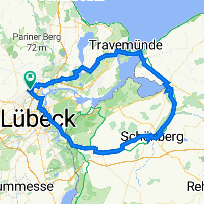
A cycling route starting in Stockelsdorf, Schleswig-Holstein, Germany.
Overview
About this route
0
null
- -:--
- Duration
- 56.5 km
- Distance
- 261 m
- Ascent
- 264 m
- Descent
- ---
- Avg. speed
- 67 m
- Max. altitude
DRÄGER - BSG Rennrad
created this 3 years ago
Part of
Nord-Routen
15 stages
Route quality
Waytypes & surfaces along the route
Waytypes
Road
20.3 km
36 %
Quiet road
13 km
23 %
Surfaces
Paved
46.3 km
(82 %)
Asphalt
40.1 km
71 %
Paved (undefined)
6.2 km
11 %
Undefined
10.2 km
18 %
Continue with Bikemap
Use, edit, or download this cycling route
You would like to ride Stodo-Heilshoop-Sühlen-Söhren-Zarpen-Stodo or customize it for your own trip? Here is what you can do with this Bikemap route:
Free features
- Save this route as favorite or in collections
- Copy & plan your own version of this route
- Sync your route with Garmin or Wahoo
Premium features
Free trial for 3 days, or one-time payment. More about Bikemap Premium.
- Navigate this route on iOS & Android
- Export a GPX / KML file of this route
- Create your custom printout (try it for free)
- Download this route for offline navigation
Discover more Premium features.
Get Bikemap PremiumFrom our community
Other popular routes starting in Stockelsdorf
- Hafen Priwall– Fähre Priwall-Travemünde Runde von Lübeck Hauptbahnhof0
- 59 km
- 126 m
- 128 m
- Stockelsdorf, Schleswig-Holstein, Germany
- Mühlenberg, Stockelsdorf nach Mühlenberg, Stockelsdorf0
- 59 km
- 315 m
- 314 m
- Stockelsdorf, Schleswig-Holstein, Germany
- Schwartau - Gothendorf - Sierksdorf - Schwartau1
- 62.2 km
- 177 m
- 176 m
- Stockelsdorf, Schleswig-Holstein, Germany
- Schwartau Schwochel Braak Sierksdorf Ruppersdorf1
- 76.4 km
- 364 m
- 364 m
- Stockelsdorf, Schleswig-Holstein, Germany


Open it in the app