

Schluckenauer Zipfeltour 5
A cycling route starting in Wilthen, Saxony, Germany.
Overview
About this route
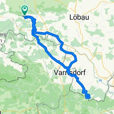
As a starting point, Haus Bergland is recommended, The route is then about 1.2 km shorter. You should be trained. Some long climbs or short steep sections. From here to Kirschau via Callenberg to Schirgeswalde. Here, before the Spree bridge, turn onto the Spree cycle path. Until the border crossing Rozany. From there to the marketplace in Sluknov (Schluckenau). About halfway, turn left and then always follow Eadweg 211. At the intersection RW211/3014, turn left onto RW 3014 towards Dymnik (Rauchberg) and follow RW 3014 until halfway in Rumburk. There, turn right into Ruzova and shortly after follow RW 3042 until the border with the FRG. There, turn left and follow RW 3043, turn into Dvorakova (leave RW3043). At the end, turn right and from there to the border. After the border, turn left and shortly after follow the Spree cycle path until behind the railway bridge in Neusalza-Spremberg. There, leave RW and turn left towards B96. Cross this and follow the Spree cycle path until the opacher Way in Taubenheim. Enter this and head towards Oppacch. Cross B96, then turn left towards Picka. Turn left onto Walweg towards Isabella. Through Callenberg, Kirschau back to the start.
- -:--
- Duration
- 66.7 km
- Distance
- 548 m
- Ascent
- 548 m
- Descent
- ---
- Avg. speed
- ---
- Max. altitude

Route quality
Waytypes & surfaces along the route
Waytypes
Quiet road
29.3 km
(44 %)
Road
16 km
(24 %)
Surfaces
Paved
28.7 km
(43 %)
Unpaved
6 km
(9 %)
Asphalt
26.7 km
(40 %)
Gravel
4 km
(6 %)
Route highlights
Points of interest along the route
Point of interest after 25.9 km
hier Radweg 211 verlassen und auf Radweg 3014 wechseln.
Continue with Bikemap
Use, edit, or download this cycling route
You would like to ride Schluckenauer Zipfeltour 5 or customize it for your own trip? Here is what you can do with this Bikemap route:
Free features
- Save this route as favorite or in collections
- Copy & plan your own version of this route
- Sync your route with Garmin or Wahoo
Premium features
Free trial for 3 days, or one-time payment. More about Bikemap Premium.
- Navigate this route on iOS & Android
- Export a GPX / KML file of this route
- Create your custom printout (try it for free)
- Download this route for offline navigation
Discover more Premium features.
Get Bikemap PremiumFrom our community
Other popular routes starting in Wilthen
 Wilthen-Buschmühe Ohorn-Wilthen
- Distance
- 65.9 km
- Ascent
- 393 m
- Descent
- 394 m
- Location
- Wilthen, Saxony, Germany
 Rund ums Oberland V6
- Distance
- 40.6 km
- Ascent
- 322 m
- Descent
- 322 m
- Location
- Wilthen, Saxony, Germany
 Wilthen-Oybin Hain Area24-Wilthen
- Distance
- 105.5 km
- Ascent
- 638 m
- Descent
- 638 m
- Location
- Wilthen, Saxony, Germany
 3-Ländertour Wilthen-Jonsdorf-Hradek nad Nisou-Bogatynia-Zittau_Wilthen
- Distance
- 126 km
- Ascent
- 851 m
- Descent
- 851 m
- Location
- Wilthen, Saxony, Germany
 Wilthen-Neustadt-Rugiswalde-Lipova-Wilthen
- Distance
- 59.7 km
- Ascent
- 446 m
- Descent
- 446 m
- Location
- Wilthen, Saxony, Germany
 Tilo nur die harten komm in Garten
- Distance
- 133 km
- Ascent
- 1,063 m
- Descent
- 1,067 m
- Location
- Wilthen, Saxony, Germany
 Butterberg-Tour V2
- Distance
- 48.3 km
- Ascent
- 415 m
- Descent
- 415 m
- Location
- Wilthen, Saxony, Germany
 Schluckenauer Zipfeltour 2
- Distance
- 69 km
- Ascent
- 492 m
- Descent
- 492 m
- Location
- Wilthen, Saxony, Germany
Open it in the app