

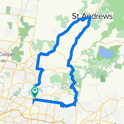
Templestowe College - Birrarung Marr
A cycling route starting in Templestowe Lower, Victoria, Australia.
Overview
About this route
VCAL WRS OHS Activity
- -:--
- Duration
- 28.5 km
- Distance
- 291 m
- Ascent
- 355 m
- Descent
- ---
- Avg. speed
- 92 m
- Avg. speed

Route quality
Waytypes & surfaces along the route
Waytypes
Cycleway
21.9 km
(77 %)
Quiet road
3.3 km
(12 %)
Surfaces
Paved
27.5 km
(96 %)
Unpaved
0 km
(<1 %)
Asphalt
15.2 km
(53 %)
Concrete
7.5 km
(26 %)
Route highlights
Points of interest along the route
Point of interest after 2.3 km
Manningham Road Crossing - Use Footbridge
Point of interest after 4 km
First Rest Point - 5mins
Point of interest after 9.7 km
Rest Break - 5mins
Point of interest after 13.3 km
Rest Break - 15mins
Continue with Bikemap
Use, edit, or download this cycling route
You would like to ride Templestowe College - Birrarung Marr or customize it for your own trip? Here is what you can do with this Bikemap route:
Free features
- Save this route as favorite or in collections
- Copy & plan your own version of this route
- Sync your route with Garmin or Wahoo
Premium features
Free trial for 3 days, or one-time payment. More about Bikemap Premium.
- Navigate this route on iOS & Android
- Export a GPX / KML file of this route
- Create your custom printout (try it for free)
- Download this route for offline navigation
Discover more Premium features.
Get Bikemap PremiumFrom our community
Other popular routes starting in Templestowe Lower
 Templestowe College - Birrarung Marr
- Distance
- 28.5 km
- Ascent
- 291 m
- Descent
- 355 m
- Location
- Templestowe Lower, Victoria, Australia
 304 High St, Templestowe Lower to 312–322 Middleborough Rd, Box Hill
- Distance
- 10.3 km
- Ascent
- 84 m
- Descent
- 93 m
- Location
- Templestowe Lower, Victoria, Australia
 Eltham Ride 2
- Distance
- 59.6 km
- Ascent
- 413 m
- Descent
- 424 m
- Location
- Templestowe Lower, Victoria, Australia
 To BHH
- Distance
- 5.5 km
- Ascent
- 102 m
- Descent
- 95 m
- Location
- Templestowe Lower, Victoria, Australia
 Ruffey Trail
- Distance
- 2.9 km
- Ascent
- 16 m
- Descent
- 56 m
- Location
- Templestowe Lower, Victoria, Australia
 Home to Work
- Distance
- 19.8 km
- Ascent
- 227 m
- Descent
- 252 m
- Location
- Templestowe Lower, Victoria, Australia
 Balmoral Avenue 19, Templestowe Lower to Barkly Place 44, Heidelberg
- Distance
- 7.3 km
- Ascent
- 133 m
- Descent
- 130 m
- Location
- Templestowe Lower, Victoria, Australia
 Manningham Road 188, Bulleen to Preston
- Distance
- 11.4 km
- Ascent
- 98 m
- Descent
- 110 m
- Location
- Templestowe Lower, Victoria, Australia
Open it in the app