

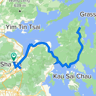
voice instructions investigation: 烏溪沙, 馬鞍山 to 青沙公路, 大圍
A cycling route starting in Shatin, Sha Tin, Hong Kong.
Overview
About this route
mostly straight section but app gives instructions "turn right"
- -:--
- Duration
- 7 km
- Distance
- 118 m
- Ascent
- 67 m
- Descent
- ---
- Avg. speed
- 59 m
- Max. altitude

Route quality
Waytypes & surfaces along the route
Waytypes
Cycleway
4.8 km
(68 %)
Quiet road
1.2 km
(17 %)
Surfaces
Paved
5.2 km
(74 %)
Paved (undefined)
5.2 km
(74 %)
Undefined
1.8 km
(26 %)
Continue with Bikemap
Use, edit, or download this cycling route
You would like to ride voice instructions investigation: 烏溪沙, 馬鞍山 to 青沙公路, 大圍 or customize it for your own trip? Here is what you can do with this Bikemap route:
Free features
- Save this route as favorite or in collections
- Copy & plan your own version of this route
- Sync your route with Garmin or Wahoo
Premium features
Free trial for 3 days, or one-time payment. More about Bikemap Premium.
- Navigate this route on iOS & Android
- Export a GPX / KML file of this route
- Create your custom printout (try it for free)
- Download this route for offline navigation
Discover more Premium features.
Get Bikemap PremiumFrom our community
Other popular routes starting in Shatin
 bike tour from (null) to (null)
- Distance
- 16.2 km
- Ascent
- 153 m
- Descent
- 152 m
- Location
- Shatin, Sha Tin, Hong Kong
 CNY 2012 Hong Kong Big Round
- Distance
- 109.2 km
- Ascent
- 398 m
- Descent
- 395 m
- Location
- Shatin, Sha Tin, Hong Kong
 Tai Wan- Fanling
- Distance
- 40.4 km
- Ascent
- 216 m
- Descent
- 203 m
- Location
- Shatin, Sha Tin, Hong Kong
 火炭~海下~火炭
- Distance
- 63.5 km
- Ascent
- 739 m
- Descent
- 722 m
- Location
- Shatin, Sha Tin, Hong Kong
 文禮路, 大圍 to Hoi Ying Rd, 馬鞍山
- Distance
- 13.5 km
- Ascent
- 154 m
- Descent
- 136 m
- Location
- Shatin, Sha Tin, Hong Kong
 Tsuen Nam Rd, Tai Wai to Tsuen Nam Rd, Tai Wai
- Distance
- 48 km
- Ascent
- 681 m
- Descent
- 673 m
- Location
- Shatin, Sha Tin, Hong Kong
 CUHK - Tai Mei Tuk
- Distance
- 17 km
- Ascent
- 72 m
- Descent
- 75 m
- Location
- Shatin, Sha Tin, Hong Kong
 Restful route
- Distance
- 33.5 km
- Ascent
- 267 m
- Descent
- 242 m
- Location
- Shatin, Sha Tin, Hong Kong
Open it in the app