

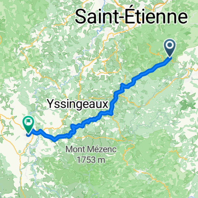
L9: Bourg-Argental - Yssingeaux; 58km 870hm
A cycling route starting in Bourg-Argental, Auvergne-Rhône-Alpes, France.
Overview
About this route
Bourg-Argental - (V73 Via Fluvia) - Saint-Meyras - La Goutte - Riotord - Dunieres - Montfaucon-en-Velay - Raucoules-Brossette - Verne - Lapte - La Chapelette - Yssingeaux
Hotel Le Bourbon, Pl. de la Victoire, 43200 Yssingeaux, France
Logis Hôtel de la Tour, 7 ter Rte du Fraisse, 43220 Dunières, France
- -:--
- Duration
- 58 km
- Distance
- 1,067 m
- Ascent
- 751 m
- Descent
- ---
- Avg. speed
- 1,025 m
- Max. altitude

Route quality
Waytypes & surfaces along the route
Waytypes
Path
33.1 km
(57 %)
Quiet road
13.3 km
(23 %)
Surfaces
Paved
44.7 km
(77 %)
Unpaved
0.6 km
(1 %)
Asphalt
44.7 km
(77 %)
Gravel
0.6 km
(1 %)
Undefined
12.8 km
(22 %)
Route highlights
Points of interest along the route
Point of interest after 0 km
Ist der Tunnel befahrbar? Sind das dann weniger Höhenmeter?
Point of interest after 2.7 km
Wasserfall La Deûme
Point of interest after 15 km
Col de Tracol Tunnel nicht befahrbar

Point of interest after 26 km
Viaduc proche de Dinieres

Point of interest after 36.8 km
VELAY-EXPRESS
Point of interest after 45.9 km
Aussichtspunkt
Point of interest after 47.9 km
Passerelle himmalzienne

Point of interest after 51 km
Pont de la Sainte

Point of interest after 51.5 km
Pont de la Chapalette

Point of interest after 58 km
Hotel Le Bourbon, 2 Pl. de la Victoire, 43200 Yssingeaux, Frankreich
Continue with Bikemap
Use, edit, or download this cycling route
You would like to ride L9: Bourg-Argental - Yssingeaux; 58km 870hm or customize it for your own trip? Here is what you can do with this Bikemap route:
Free features
- Save this route as favorite or in collections
- Copy & plan your own version of this route
- Sync your route with Garmin or Wahoo
Premium features
Free trial for 3 days, or one-time payment. More about Bikemap Premium.
- Navigate this route on iOS & Android
- Export a GPX / KML file of this route
- Create your custom printout (try it for free)
- Download this route for offline navigation
Discover more Premium features.
Get Bikemap PremiumFrom our community
Other popular routes starting in Bourg-Argental
 parcours III Bourg St sauveur
- Distance
- 51.2 km
- Ascent
- 981 m
- Descent
- 724 m
- Location
- Bourg-Argental, Auvergne-Rhône-Alpes, France
 L9: Bourg-Argental - Yssingeaux; 58km 870hm
- Distance
- 58 km
- Ascent
- 1,067 m
- Descent
- 751 m
- Location
- Bourg-Argental, Auvergne-Rhône-Alpes, France
 So 14.8. Ardechoise - Der Norden
- Distance
- 105.1 km
- Ascent
- 2,660 m
- Descent
- 3,131 m
- Location
- Bourg-Argental, Auvergne-Rhône-Alpes, France
 De Route de Badol 1010, Saint-Sauveur-en-Rue à L'Homme 103, Burdignes
- Distance
- 4 km
- Ascent
- 13 m
- Descent
- 163 m
- Location
- Bourg-Argental, Auvergne-Rhône-Alpes, France
 Bourg-Argental - Le Puy-en-Velay
- Distance
- 87.8 km
- Ascent
- 752 m
- Descent
- 729 m
- Location
- Bourg-Argental, Auvergne-Rhône-Alpes, France
 Parcours II Bourg Vanosc montfaucon le villard
- Distance
- 59.1 km
- Ascent
- 1,196 m
- Descent
- 935 m
- Location
- Bourg-Argental, Auvergne-Rhône-Alpes, France
 Bourg-Argental / St Félicien 62km
- Distance
- 62.1 km
- Ascent
- 1,310 m
- Descent
- 1,307 m
- Location
- Bourg-Argental, Auvergne-Rhône-Alpes, France
 parcours I Bourg Bessat jonzieux sigolène
- Distance
- 65.5 km
- Ascent
- 1,068 m
- Descent
- 809 m
- Location
- Bourg-Argental, Auvergne-Rhône-Alpes, France
Open it in the app