
Maďarsko 2011
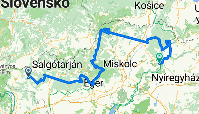
A cycling route starting in Romhány, Nógrád megye, Hungary.
Overview
About this route
Cycling trip with Adventura through the mountains and vineyards in northeastern Hungary. Flat sections - completed by bus.
- -:--
- Duration
- 441.8 km
- Distance
- 2,335 m
- Ascent
- 2,425 m
- Descent
- ---
- Avg. speed
- ---
- Max. altitude
Route quality
Waytypes & surfaces along the route
Waytypes
Quiet road
97.2 km
(22 %)
Track
88.4 km
(20 %)
Surfaces
Paved
150.2 km
(34 %)
Unpaved
48.6 km
(11 %)
Asphalt
145.8 km
(33 %)
Ground
30.9 km
(7 %)
Continue with Bikemap
Use, edit, or download this cycling route
You would like to ride Maďarsko 2011 or customize it for your own trip? Here is what you can do with this Bikemap route:
Free features
- Save this route as favorite or in collections
- Copy & plan your own version of this route
- Split it into stages to create a multi-day tour
- Sync your route with Garmin or Wahoo
Premium features
Free trial for 3 days, or one-time payment. More about Bikemap Premium.
- Navigate this route on iOS & Android
- Export a GPX / KML file of this route
- Create your custom printout (try it for free)
- Download this route for offline navigation
Discover more Premium features.
Get Bikemap PremiumFrom our community
Other popular routes starting in Romhány
 Magyarnándor-Terény-Becske-Erdőkertes
- Distance
- 56 km
- Ascent
- 379 m
- Descent
- 368 m
- Location
- Romhány, Nógrád megye, Hungary
 Börzsöny 2.nap 2016
- Distance
- 100.4 km
- Ascent
- 731 m
- Descent
- 734 m
- Location
- Romhány, Nógrád megye, Hungary
 Börzsöny 3.nap 2016
- Distance
- 119.3 km
- Ascent
- 1,195 m
- Descent
- 1,236 m
- Location
- Romhány, Nógrád megye, Hungary
 Kétbodony-kör
- Distance
- 43.6 km
- Ascent
- 458 m
- Descent
- 458 m
- Location
- Romhány, Nógrád megye, Hungary
 Route from Petőfi Sándor út 75., Legénd Tanya
- Distance
- 1.6 km
- Ascent
- 28 m
- Descent
- 13 m
- Location
- Romhány, Nógrád megye, Hungary
 Nógrádi 77km körtúra
- Distance
- 76.9 km
- Ascent
- 459 m
- Descent
- 459 m
- Location
- Romhány, Nógrád megye, Hungary
 Magyarnándor - Szanda - Buják - Pásztó
- Distance
- 46.6 km
- Ascent
- 647 m
- Descent
- 684 m
- Location
- Romhány, Nógrád megye, Hungary
 Budapest-Romhány kör 2. nap
- Distance
- 71.7 km
- Ascent
- 306 m
- Descent
- 348 m
- Location
- Romhány, Nógrád megye, Hungary
Open it in the app