

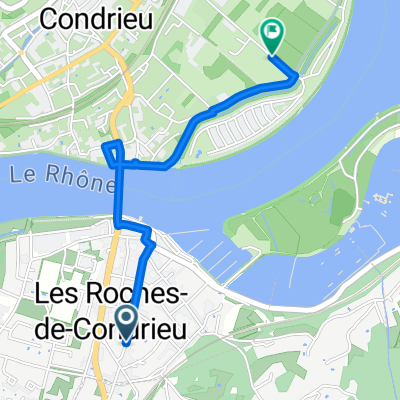
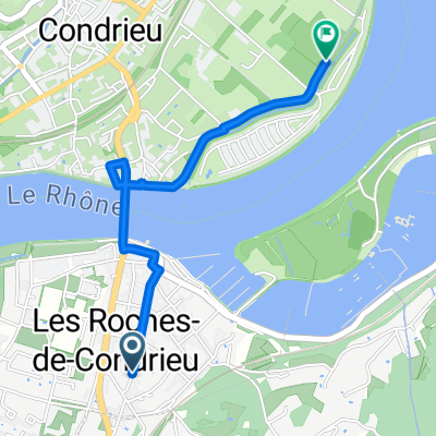
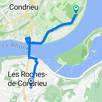
L8: Les-Roches-de-Condrieu - Bourg-Argental; 62,8km 690hm
A cycling route starting in Les Roches-de-Condrieu, Auvergne-Rhône-Alpes, France.
Overview
About this route
Les-Roches-de-Condrieu - (VR Via Rhona) - Verin - Les Iles - Sablons - Serrieres - (Via Fluvia V73, nicht ausgeschildert) - Peyraud - Les Parzines - Clava - Les Barges - Les Gardonnes - [deviating route via Solore - Saint-Cyr - Pra Mouriau - Midon) - (V73 Via Fluvia, possibly not yet signposted) - La Gare - Le Mourio - Annonay - (V73 Via Fluvia, signposted) - Vidalon - Verney - Saint-Marcel-les-Annonay - Bourg-Argental
Hotel Restaurant Le Relais, 35 Rue du Dr Guyotat, 42220 Bourg-Argental, Frankreich
- -:--
- Duration
- 62.8 km
- Distance
- 868 m
- Ascent
- 474 m
- Descent
- ---
- Avg. speed
- 609 m
- Max. altitude

Route quality
Waytypes & surfaces along the route
Waytypes
Path
18.8 km
(30 %)
Cycleway
17.6 km
(28 %)
Surfaces
Paved
39.6 km
(63 %)
Unpaved
1.3 km
(2 %)
Asphalt
38.9 km
(62 %)
Paved (undefined)
0.6 km
(1 %)
Route highlights
Points of interest along the route

Point of interest after 0 km
Base Nautique de Condrieu - Les Roches

Point of interest after 11.1 km
Space Eaux Vives

Point of interest after 31.9 km
Aqueduc et château de Thorenc
Point of interest after 31.9 km
Geradeaus Weiterfahren auf der Via Fluvia, falls möglich
Point of interest after 34.5 km
Links zur V73 Via Fluvia oder geradeaus direkt nach Annonay
Point of interest after 40.8 km
Geradeaus weiterfahren, wenn möglich
Point of interest after 42 km
Geradeaus weiterfahren, wenn möglich
Point of interest after 43.2 km
Links abbiegen und auf der Via Fluvia bleiben
Point of interest after 61.1 km
Tunnel du Tarcot Keine Ahnung, ob er befahrbar ist

Accommodation after 62.8 km
Hotel Restaurant Le Relais, 35 Rue du Dr Guyotat, 42220 Bourg-Argental, Frankreich
Continue with Bikemap
Use, edit, or download this cycling route
You would like to ride L8: Les-Roches-de-Condrieu - Bourg-Argental; 62,8km 690hm or customize it for your own trip? Here is what you can do with this Bikemap route:
Free features
- Save this route as favorite or in collections
- Copy & plan your own version of this route
- Sync your route with Garmin or Wahoo
Premium features
Free trial for 3 days, or one-time payment. More about Bikemap Premium.
- Navigate this route on iOS & Android
- Export a GPX / KML file of this route
- Create your custom printout (try it for free)
- Download this route for offline navigation
Discover more Premium features.
Get Bikemap PremiumFrom our community
Other popular routes starting in Les Roches-de-Condrieu
 De Avenue de la Gare à Chemin du Camping
- Distance
- 2.3 km
- Ascent
- 4 m
- Descent
- 14 m
- Location
- Les Roches-de-Condrieu, Auvergne-Rhône-Alpes, France
 L8: Les-Roches-de-Condrieu - Bourg-Argental; 62,8km 690hm
- Distance
- 62.8 km
- Ascent
- 868 m
- Descent
- 474 m
- Location
- Les Roches-de-Condrieu, Auvergne-Rhône-Alpes, France
 De Avenue de la Gare à Chemin du Camping
- Distance
- 2.3 km
- Ascent
- 4 m
- Descent
- 14 m
- Location
- Les Roches-de-Condrieu, Auvergne-Rhône-Alpes, France
 Saint-Clair-du-Rhône to 10 Allée des Petits Champs, Valence
- Distance
- 81.4 km
- Ascent
- 276 m
- Descent
- 320 m
- Location
- Les Roches-de-Condrieu, Auvergne-Rhône-Alpes, France
 journée 2 jusque Saint Jean de muzols
- Distance
- 57.1 km
- Ascent
- 560 m
- Descent
- 695 m
- Location
- Les Roches-de-Condrieu, Auvergne-Rhône-Alpes, France
 De Avenue de la Gare à Chemin du Camping
- Distance
- 2.3 km
- Ascent
- 4 m
- Descent
- 14 m
- Location
- Les Roches-de-Condrieu, Auvergne-Rhône-Alpes, France
 De 5 Sente Béatrice de Roussillon, Vérin à Route de l'Œillon, Véranne
- Distance
- 25.4 km
- Ascent
- 1,146 m
- Descent
- 61 m
- Location
- Les Roches-de-Condrieu, Auvergne-Rhône-Alpes, France
 5 Rue de la Décize, Les Roches-de-Condrieu to 5 Rue de la Décize, Les Roches-de-Condrieu
- Distance
- 4.2 km
- Ascent
- 290 m
- Descent
- 291 m
- Location
- Les Roches-de-Condrieu, Auvergne-Rhône-Alpes, France
Open it in the app