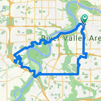
11830 101 St NW, Edmonton to 10419 124 St NW, Edmonton
A cycling route starting in Edmonton, Alberta, Canada.
Overview
About this route
null
- 23 min
- Duration
- 5.3 km
- Distance
- 0 m
- Ascent
- 0 m
- Descent
- 14 km/h
- Avg. speed
- 670 m
- Avg. speed
Route quality
Waytypes & surfaces along the route
Waytypes
Quiet road
2 km
(37 %)
Pedestrian area
2 km
(37 %)
Surfaces
Paved
3.5 km
(65 %)
Asphalt
2.1 km
(40 %)
Concrete
1 km
(18 %)
Continue with Bikemap
Use, edit, or download this cycling route
You would like to ride 11830 101 St NW, Edmonton to 10419 124 St NW, Edmonton or customize it for your own trip? Here is what you can do with this Bikemap route:
Free features
- Save this route as favorite or in collections
- Copy & plan your own version of this route
- Sync your route with Garmin or Wahoo
Premium features
Free trial for 3 days, or one-time payment. More about Bikemap Premium.
- Navigate this route on iOS & Android
- Export a GPX / KML file of this route
- Create your custom printout (try it for free)
- Download this route for offline navigation
Discover more Premium features.
Get Bikemap PremiumFrom our community
Other popular routes starting in Edmonton
- Edmonton River Valley SW 34k
- Distance
- 34.3 km
- Ascent
- 394 m
- Descent
- 393 m
- Location
- Edmonton, Alberta, Canada
- Relaxed route in Edmonton
- Distance
- 19.1 km
- Ascent
- 1,710 m
- Descent
- 1,712 m
- Location
- Edmonton, Alberta, Canada
- 12905 96 St NW, Edmonton to 10473 River Valley Rd NW, Edmonton
- Distance
- 16.3 km
- Ascent
- 38 m
- Descent
- 86 m
- Location
- Edmonton, Alberta, Canada
- Edmonton - Sherwood Park
- Distance
- 21.8 km
- Ascent
- 164 m
- Descent
- 138 m
- Location
- Edmonton, Alberta, Canada
- Fer Rundle
- Distance
- 38.3 km
- Ascent
- 447 m
- Descent
- 447 m
- Location
- Edmonton, Alberta, Canada
- South West of Edmonton - Rabbit Hills Cycle out of city
- Distance
- 48.9 km
- Ascent
- 104 m
- Descent
- 105 m
- Location
- Edmonton, Alberta, Canada
- Saskatchewan Drive Northwest 11154, Edmonton to Queen Elizabeth Park Road 10559, Edmonton
- Distance
- 16.3 km
- Ascent
- 360 m
- Descent
- 364 m
- Location
- Edmonton, Alberta, Canada
- River Valley NE from Mill Creek
- Distance
- 33.8 km
- Ascent
- 220 m
- Descent
- 220 m
- Location
- Edmonton, Alberta, Canada
Open it in the app