

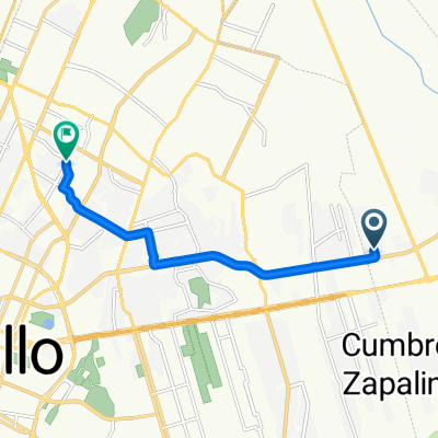
25.450° N -100.848° W a 25.489° N -100.763° W
A cycling route starting in Arteaga, Coahuila, Mexico.
Overview
About this route
- 1 h 21 min
- Duration
- 10.3 km
- Distance
- 263 m
- Ascent
- 39 m
- Descent
- 7.6 km/h
- Avg. speed
- 1,911 m
- Max. altitude
Route quality
Waytypes & surfaces along the route
Waytypes
Quiet road
10.3 km
(100 %)
Surfaces
Unpaved
9.5 km
(93 %)
Unpaved (undefined)
9.5 km
(93 %)
Undefined
0.7 km
(7 %)
Continue with Bikemap
Use, edit, or download this cycling route
You would like to ride 25.450° N -100.848° W a 25.489° N -100.763° W or customize it for your own trip? Here is what you can do with this Bikemap route:
Free features
- Save this route as favorite or in collections
- Copy & plan your own version of this route
- Sync your route with Garmin or Wahoo
Premium features
Free trial for 3 days, or one-time payment. More about Bikemap Premium.
- Navigate this route on iOS & Android
- Export a GPX / KML file of this route
- Create your custom printout (try it for free)
- Download this route for offline navigation
Discover more Premium features.
Get Bikemap PremiumFrom our community
Other popular routes starting in Arteaga
 De Valle del Oriente a Boulevard Rufino Tamayo
- Distance
- 9.7 km
- Ascent
- 16 m
- Descent
- 80 m
- Location
- Arteaga, Coahuila, Mexico
 Cañon de La Roja - Carbonera
- Distance
- 61.6 km
- Ascent
- 1,133 m
- Descent
- 1,134 m
- Location
- Arteaga, Coahuila, Mexico
 Boulevard Terranova, Saltillo a Boulevard los Fundadores 1018, Arteaga
- Distance
- 11.3 km
- Ascent
- 169 m
- Descent
- 20 m
- Location
- Arteaga, Coahuila, Mexico
 Arteaga/terraserenna
- Distance
- 10.5 km
- Ascent
- 192 m
- Descent
- 18 m
- Location
- Arteaga, Coahuila, Mexico
 Valle del Oriente - Arteaga
- Distance
- 13.9 km
- Ascent
- 136 m
- Descent
- 119 m
- Location
- Arteaga, Coahuila, Mexico
 CHORROS-LAGUNA DE SANCHEZ
- Distance
- 119.7 km
- Ascent
- 2,143 m
- Descent
- 2,143 m
- Location
- Arteaga, Coahuila, Mexico
 Paseo del Terrado, Saltillo a Paseo del Terrado, Saltillo
- Distance
- 29.2 km
- Ascent
- 246 m
- Descent
- 241 m
- Location
- Arteaga, Coahuila, Mexico
 De Río Grijalva a Boulevard Eulalio Gutiérrez Treviño
- Distance
- 10.4 km
- Ascent
- 34 m
- Descent
- 107 m
- Location
- Arteaga, Coahuila, Mexico
Open it in the app