

ein paar Hügel im Wienerwald
A cycling route starting in Münchendorf, Lower Austria, Austria.
Overview
About this route
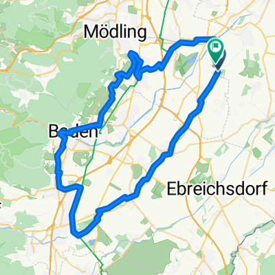
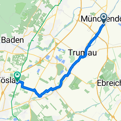
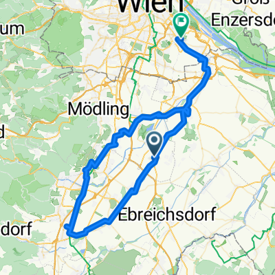
Münchendorf - Bad Vöslau - Schwarzensee - Nayerling - Heiliegkreuz - Gaaden - Einöd/Pfaffstätten - Münchendorf
- -:--
- Duration
- 67.5 km
- Distance
- 637 m
- Ascent
- 638 m
- Descent
- ---
- Avg. speed
- ---
- Max. altitude

Route quality
Waytypes & surfaces along the route
Waytypes
Road
27.7 km
(41 %)
Cycleway
9.5 km
(14 %)
Surfaces
Paved
46.6 km
(69 %)
Unpaved
1.4 km
(2 %)
Asphalt
45.9 km
(68 %)
Paved (undefined)
0.7 km
(1 %)
Continue with Bikemap
Use, edit, or download this cycling route
You would like to ride ein paar Hügel im Wienerwald or customize it for your own trip? Here is what you can do with this Bikemap route:
Free features
- Save this route as favorite or in collections
- Copy & plan your own version of this route
- Sync your route with Garmin or Wahoo
Premium features
Free trial for 3 days, or one-time payment. More about Bikemap Premium.
- Navigate this route on iOS & Android
- Export a GPX / KML file of this route
- Create your custom printout (try it for free)
- Download this route for offline navigation
Discover more Premium features.
Get Bikemap PremiumFrom our community
Other popular routes starting in Münchendorf
 ein paar Hügel im Wienerwald
- Distance
- 67.5 km
- Ascent
- 637 m
- Descent
- 638 m
- Location
- Münchendorf, Lower Austria, Austria
 Münchendorf - Richardshof
- Distance
- 12.7 km
- Ascent
- 198 m
- Descent
- 17 m
- Location
- Münchendorf, Lower Austria, Austria
 Gumpoldskirchen-Kottingbrunn-Baden
- Distance
- 62.6 km
- Ascent
- 249 m
- Descent
- 251 m
- Location
- Münchendorf, Lower Austria, Austria
 flat as pancake
- Distance
- 45.9 km
- Ascent
- 57 m
- Descent
- 62 m
- Location
- Münchendorf, Lower Austria, Austria
 Münchendorf - Schönau Runde über EV9/Neustädter Kanal
- Distance
- 39.3 km
- Ascent
- 79 m
- Descent
- 66 m
- Location
- Münchendorf, Lower Austria, Austria
 Ried in der Au, Münchendorf nach Ahorngasse, Kottingbrunn
- Distance
- 17.8 km
- Ascent
- 66 m
- Descent
- 16 m
- Location
- Münchendorf, Lower Austria, Austria
 Mdf. - Kleinfeld/Berndorf
- Distance
- 31.1 km
- Ascent
- 201 m
- Descent
- 30 m
- Location
- Münchendorf, Lower Austria, Austria
 Ödenburger Straße to Kaiser-Ebersdorfer-Straße
- Distance
- 101.7 km
- Ascent
- 208 m
- Descent
- 231 m
- Location
- Münchendorf, Lower Austria, Austria
Open it in the app