

Vetta Amiata
A cycling route starting in Santa Fiora, Tuscany, Italy.
Overview
About this route
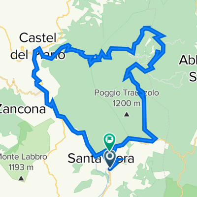
Vetta Amiata
up from Aiole
down to Abbadia S.Salvatore
up from Piancastagnaio
down to Aiole
- -:--
- Duration
- 49.3 km
- Distance
- 1,534 m
- Ascent
- 1,552 m
- Descent
- ---
- Avg. speed
- ---
- Max. altitude
Continue with Bikemap
Use, edit, or download this cycling route
You would like to ride Vetta Amiata or customize it for your own trip? Here is what you can do with this Bikemap route:
Free features
- Save this route as favorite or in collections
- Copy & plan your own version of this route
- Sync your route with Garmin or Wahoo
Premium features
Free trial for 3 days, or one-time payment. More about Bikemap Premium.
- Navigate this route on iOS & Android
- Export a GPX / KML file of this route
- Create your custom printout (try it for free)
- Download this route for offline navigation
Discover more Premium features.
Get Bikemap PremiumFrom our community
Other popular routes starting in Santa Fiora
 Vetta Amiata
- Distance
- 49.3 km
- Ascent
- 1,534 m
- Descent
- 1,552 m
- Location
- Santa Fiora, Tuscany, Italy
 Amiato via San Lorenzo
- Distance
- 43.5 km
- Ascent
- 1,512 m
- Descent
- 1,345 m
- Location
- Santa Fiora, Tuscany, Italy
 04 bagnore
- Distance
- 5.2 km
- Ascent
- 39 m
- Descent
- 204 m
- Location
- Santa Fiora, Tuscany, Italy
 2019-3 Santa Fiora
- Distance
- 50.7 km
- Ascent
- 1,256 m
- Descent
- 1,256 m
- Location
- Santa Fiora, Tuscany, Italy
 2019-2 Santa Fiora
- Distance
- 56.8 km
- Ascent
- 1,029 m
- Descent
- 1,029 m
- Location
- Santa Fiora, Tuscany, Italy
 2019 SFiora-CastelAzzara
- Distance
- 52.3 km
- Ascent
- 1,038 m
- Descent
- 1,038 m
- Location
- Santa Fiora, Tuscany, Italy
 hora 1700
- Distance
- 9.9 km
- Ascent
- 803 m
- Descent
- 40 m
- Location
- Santa Fiora, Tuscany, Italy
 Santa Fiora - Amiata - Montalcino
- Distance
- 110.9 km
- Ascent
- 2,409 m
- Descent
- 2,389 m
- Location
- Santa Fiora, Tuscany, Italy
Open it in the app