

TET_PL-01_20220823 - TET_PL-02_20220823 - TET_PL-03_20220823 - TET_PL-05_20220823
A cycling route starting in Krasnopol, Podlasie Voivodship, Poland.
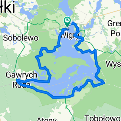
Overview
About this route
- -:--
- Duration
- 196.6 km
- Distance
- 1,443 m
- Ascent
- 1,440 m
- Descent
- ---
- Avg. speed
- 255 m
- Max. altitude

Route quality
Waytypes & surfaces along the route
Waytypes
Quiet road
82.6 km
(42 %)
Road
55 km
(28 %)
Surfaces
Paved
84.5 km
(43 %)
Unpaved
68.8 km
(35 %)
Asphalt
74.7 km
(38 %)
Gravel
35.4 km
(18 %)
Route highlights
Points of interest along the route
Point of interest after 80.5 km
Continue with Bikemap
Use, edit, or download this cycling route
You would like to ride TET_PL-01_20220823 - TET_PL-02_20220823 - TET_PL-03_20220823 - TET_PL-05_20220823 or customize it for your own trip? Here is what you can do with this Bikemap route:
Free features
- Save this route as favorite or in collections
- Copy & plan your own version of this route
- Split it into stages to create a multi-day tour
- Sync your route with Garmin or Wahoo
Premium features
Free trial for 3 days, or one-time payment. More about Bikemap Premium.
- Navigate this route on iOS & Android
- Export a GPX / KML file of this route
- Create your custom printout (try it for free)
- Download this route for offline navigation
Discover more Premium features.
Get Bikemap PremiumFrom our community
Other popular routes starting in Krasnopol
 jez.Wigry
- Distance
- 41.9 km
- Ascent
- 239 m
- Descent
- 239 m
- Location
- Krasnopol, Podlasie Voivodship, Poland
 Wycieczka Nr 7/2010 - Wigierski Park Narodowy - 21 maja
- Distance
- 58 km
- Ascent
- 201 m
- Descent
- 201 m
- Location
- Krasnopol, Podlasie Voivodship, Poland
 Wokół Wigier
- Distance
- 46.1 km
- Ascent
- 215 m
- Descent
- 211 m
- Location
- Krasnopol, Podlasie Voivodship, Poland
 Wigry
Wigry- Distance
- 46.8 km
- Ascent
- 203 m
- Descent
- 201 m
- Location
- Krasnopol, Podlasie Voivodship, Poland
 Mikołajewo Maćkowa Ruda Czerwony Krzyż
- Distance
- 19.5 km
- Ascent
- 104 m
- Descent
- 100 m
- Location
- Krasnopol, Podlasie Voivodship, Poland
 20170615 (czwartek) Wigry - Goniądz
- Distance
- 106.1 km
- Ascent
- 196 m
- Descent
- 204 m
- Location
- Krasnopol, Podlasie Voivodship, Poland
 Bryzgiel - Suwałki
- Distance
- 20.1 km
- Ascent
- 85 m
- Descent
- 57 m
- Location
- Krasnopol, Podlasie Voivodship, Poland
 Dookoła Wigier
- Distance
- 44 km
- Ascent
- 213 m
- Descent
- 218 m
- Location
- Krasnopol, Podlasie Voivodship, Poland
Open it in the app