

3. Tag Prunieres - Sisteron
A cycling route starting in Chorges, Provence-Alpes-Côte d'Azur Region, France.
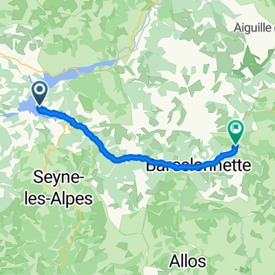
Overview
About this route
- -:--
- Duration
- 91.5 km
- Distance
- 651 m
- Ascent
- 948 m
- Descent
- ---
- Avg. speed
- ---
- Max. altitude

Route highlights
Points of interest along the route

Point of interest after 0.3 km
Chapelle de Serre-Ponçon

Point of interest after 30.9 km
Jour de pêche

Point of interest after 41.1 km
Castle

Point of interest after 88.8 km
Camping Municipal

Point of interest after 91 km
Sisteron

Point of interest after 91.5 km
Cathédrale de Sisteron
Continue with Bikemap
Use, edit, or download this cycling route
You would like to ride 3. Tag Prunieres - Sisteron or customize it for your own trip? Here is what you can do with this Bikemap route:
Free features
- Save this route as favorite or in collections
- Copy & plan your own version of this route
- Split it into stages to create a multi-day tour
- Sync your route with Garmin or Wahoo
Premium features
Free trial for 3 days, or one-time payment. More about Bikemap Premium.
- Navigate this route on iOS & Android
- Export a GPX / KML file of this route
- Create your custom printout (try it for free)
- Download this route for offline navigation
Discover more Premium features.
Get Bikemap PremiumFrom our community
Other popular routes starting in Chorges
 Serre Ponçon N°2(1)96kms 2600D+ ou 80kms D+1900
- Distance
- 96 km
- Ascent
- 2,916 m
- Descent
- 2,915 m
- Location
- Chorges, Provence-Alpes-Côte d'Azur Region, France
 Von Le Sauze-du-Lac bis Jausiers
- Distance
- 42.7 km
- Ascent
- 1,053 m
- Descent
- 871 m
- Location
- Chorges, Provence-Alpes-Côte d'Azur Region, France
 chorges n°3
- Distance
- 7.1 km
- Ascent
- 188 m
- Descent
- 221 m
- Location
- Chorges, Provence-Alpes-Côte d'Azur Region, France
 3. Tag Prunieres - Sisteron
- Distance
- 91.5 km
- Ascent
- 651 m
- Descent
- 948 m
- Location
- Chorges, Provence-Alpes-Côte d'Azur Region, France
 Sud de Serre-Ponçon et Gap
- Distance
- 118.3 km
- Ascent
- 1,522 m
- Descent
- 1,519 m
- Location
- Chorges, Provence-Alpes-Côte d'Azur Region, France
 Serre-Ponçon - Orcières-Merlette
- Distance
- 138.4 km
- Ascent
- 2,971 m
- Descent
- 2,972 m
- Location
- Chorges, Provence-Alpes-Côte d'Azur Region, France
 chorges montgardin batie neuve
- Distance
- 17.3 km
- Ascent
- 313 m
- Descent
- 311 m
- Location
- Chorges, Provence-Alpes-Côte d'Azur Region, France
 Serre Ponçon cime de la bonnette -150KMS
- Distance
- 65 km
- Ascent
- 2,322 m
- Descent
- 660 m
- Location
- Chorges, Provence-Alpes-Côte d'Azur Region, France
Open it in the app