

4. Tag Sisteron - Moustiers
A cycling route starting in Sisteron, Provence-Alpes-Côte d'Azur Region, France.
Overview
About this route
- -:--
- Duration
- 88.8 km
- Distance
- 722 m
- Ascent
- 613 m
- Descent
- ---
- Avg. speed
- ---
- Max. altitude

Route quality
Waytypes & surfaces along the route
Waytypes
Track
31.1 km
(35 %)
Quiet road
21.3 km
(24 %)
Surfaces
Paved
37.3 km
(42 %)
Unpaved
11.5 km
(13 %)
Asphalt
34.6 km
(39 %)
Gravel
8 km
(9 %)
Route highlights
Points of interest along the route

Point of interest after 0.2 km
Citadel of Sisteron

Point of interest after 14.6 km
Les tours de Volonne

Point of interest after 25.5 km
Les Mées vu en Parapente

Point of interest after 69.7 km
Espinouse

Point of interest after 73 km
Dead tree and live fields

Point of interest after 76.8 km
Puimoisson

Point of interest after 86.3 km
MOUSTIER SAINTE MARIE

Point of interest after 88.8 km
Moustiers-Sainte-Marie
Continue with Bikemap
Use, edit, or download this cycling route
You would like to ride 4. Tag Sisteron - Moustiers or customize it for your own trip? Here is what you can do with this Bikemap route:
Free features
- Save this route as favorite or in collections
- Copy & plan your own version of this route
- Split it into stages to create a multi-day tour
- Sync your route with Garmin or Wahoo
Premium features
Free trial for 3 days, or one-time payment. More about Bikemap Premium.
- Navigate this route on iOS & Android
- Export a GPX / KML file of this route
- Create your custom printout (try it for free)
- Download this route for offline navigation
Discover more Premium features.
Get Bikemap PremiumFrom our community
Other popular routes starting in Sisteron
 Sisteron - Circle to Claret
- Distance
- 54.3 km
- Ascent
- 798 m
- Descent
- 797 m
- Location
- Sisteron, Provence-Alpes-Côte d'Azur Region, France
 Durance - Buech - Eygues
- Distance
- 306.8 km
- Ascent
- 1,098 m
- Descent
- 1,111 m
- Location
- Sisteron, Provence-Alpes-Côte d'Azur Region, France
 Sisteron - Circle to Clamensane and beyond
- Distance
- 58.8 km
- Ascent
- 662 m
- Descent
- 662 m
- Location
- Sisteron, Provence-Alpes-Côte d'Azur Region, France
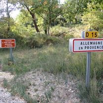 Sisteron to Allemagne-en-Provence
- Distance
- 66.6 km
- Ascent
- 897 m
- Descent
- 942 m
- Location
- Sisteron, Provence-Alpes-Côte d'Azur Region, France
 Alpentocht 2015 alternatief dag 4: Sisteron - Sault
- Distance
- 113 km
- Ascent
- 1,848 m
- Descent
- 1,589 m
- Location
- Sisteron, Provence-Alpes-Côte d'Azur Region, France
 4. Tag Sisteron - Moustiers
- Distance
- 88.8 km
- Ascent
- 722 m
- Descent
- 613 m
- Location
- Sisteron, Provence-Alpes-Côte d'Azur Region, France
 Gap to Digne to Château-Arnoux-Saint-Auban
- Distance
- 73.1 km
- Ascent
- 344 m
- Descent
- 376 m
- Location
- Sisteron, Provence-Alpes-Côte d'Azur Region, France
 Sisteron - Circle to Peipin
- Distance
- 14.8 km
- Ascent
- 145 m
- Descent
- 138 m
- Location
- Sisteron, Provence-Alpes-Côte d'Azur Region, France
Open it in the app