EDGE EXPLORE2®
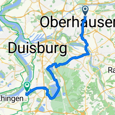
mit dem Rad von Oberhausen am Rhein-Herne-Kanal entlang- 15.9 km
- 39 m
- 32 m
- Oberhausen, North Rhine-Westphalia, Germany
A cycling route starting in Oberhausen, North Rhine-Westphalia, Germany.
Overview
Famileintaugliche Route, die zu der höchsten begehbaren Halde im Ruhrgebiet führt. Diese Tour verläuft aber nur am Fuße der Halde. Rauf geht's bei einer anderen Tour. Auf dem Rückweg wird ein kleines Stück auf Strasse gefahren. Ansonsten nur Radwanderwege oder ehemalige Bahntrassen.
created this 3 years ago
Route quality
Track
13.8 km
(43 %)
Path
12.5 km
(39 %)
Paved
9 km
(28 %)
Unpaved
21.4 km
(67 %)
Gravel
15.4 km
(48 %)
Asphalt
9 km
(28 %)
Continue with Bikemap
You would like to ride Haniel- & Halde Schöttelheide or customize it for your own trip? Here is what you can do with this Bikemap route:
Free trial for 3 days, or one-time payment. More about Bikemap Premium.
Discover more Premium features.
Get Bikemap PremiumFrom our community
EDGE EXPLORE2®
mit dem Rad von Oberhausen am Rhein-Herne-Kanal entlangOpen it in the app