

Track_Gravel_Long_final
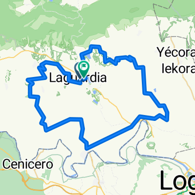
A cycling route starting in Laguardia, Basque Country, Spain.
Overview
About this route
Estadísticas calculadas a partir de los datos importadosmiércoles 14 de septiembre de 2022 6:47 CESTDistancia: 102,4 kmDuración: 9 horas, 23 minutos y 25 segundosVelocidad media: 10,9 km/hElevación mínima: 392 mElevación máxima: 684 mAscenso total: 1275 mDescenso total: 1278 m
- -:--
- Duration
- 109.2 km
- Distance
- 1,376 m
- Ascent
- 1,381 m
- Descent
- ---
- Avg. speed
- 680 m
- Max. altitude

Route quality
Waytypes & surfaces along the route
Waytypes
Track
86.3 km
(79 %)
Quiet road
12 km
(11 %)
Surfaces
Paved
32.8 km
(30 %)
Unpaved
20.7 km
(19 %)
Paved (undefined)
29.5 km
(27 %)
Gravel
16.4 km
(15 %)
Continue with Bikemap
Use, edit, or download this cycling route
You would like to ride Track_Gravel_Long_final or customize it for your own trip? Here is what you can do with this Bikemap route:
Free features
- Save this route as favorite or in collections
- Copy & plan your own version of this route
- Split it into stages to create a multi-day tour
- Sync your route with Garmin or Wahoo
Premium features
Free trial for 3 days, or one-time payment. More about Bikemap Premium.
- Navigate this route on iOS & Android
- Export a GPX / KML file of this route
- Create your custom printout (try it for free)
- Download this route for offline navigation
Discover more Premium features.
Get Bikemap PremiumFrom our community
Other popular routes starting in Laguardia
 Strava Finca Martelo Orbea Gravel 2022
- Distance
- 1.7 km
- Ascent
- 66 m
- Descent
- 28 m
- Location
- Laguardia, Basque Country, Spain
 FUENTES del VINO stage 4
- Distance
- 115.1 km
- Ascent
- 1,516 m
- Descent
- 1,515 m
- Location
- Laguardia, Basque Country, Spain
 logroño
- Distance
- 39.9 km
- Ascent
- 1,282 m
- Descent
- 804 m
- Location
- Laguardia, Basque Country, Spain
 GRAVEL 2 LAGUARDIA 60 KM - GRAVEL 2 LAGUARDIA 60 KM
- Distance
- 57.5 km
- Ascent
- 1,132 m
- Descent
- 1,151 m
- Location
- Laguardia, Basque Country, Spain
 TrackOficial_Gravel_Long_2022_v.13.09.22
- Distance
- 102.4 km
- Ascent
- 1,234 m
- Descent
- 1,239 m
- Location
- Laguardia, Basque Country, Spain
 Short Track Orbea Gravel 2024
- Distance
- 53.5 km
- Ascent
- 994 m
- Descent
- 999 m
- Location
- Laguardia, Basque Country, Spain
 De herrera a Pipaon
- Distance
- 16 km
- Ascent
- 587 m
- Descent
- 347 m
- Location
- Laguardia, Basque Country, Spain
 Fuentes del Vino - Version 5 days
- Distance
- 458.7 km
- Ascent
- 4,091 m
- Descent
- 4,092 m
- Location
- Laguardia, Basque Country, Spain
Open it in the app