
Einmal Rund um den Fremersberg
A cycling route starting in Ottenhofen, Baden-Wurttemberg, Germany.
Overview
About this route
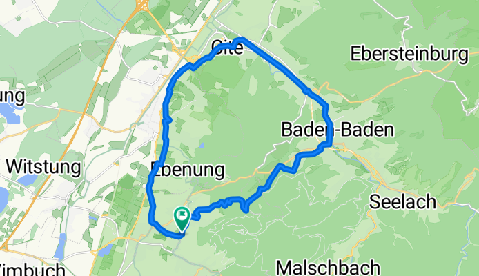
This tour can be comfortably completed in 1 -1.5 hours and its slope goes through a cool forest, the descent passes by the golf course and the SWR down into the town of Baden-Baden, passing by the Frieder Burda Museum and casino as well as the drinking hall, then it’s always slightly downhill to the new district Cité. Then back to Sinzheim and Steinbach.
Have fun
- -:--
- Duration
- 20.4 km
- Distance
- 246 m
- Ascent
- 246 m
- Descent
- ---
- Avg. speed
- ---
- Max. altitude
Route quality
Waytypes & surfaces along the route
Waytypes
Quiet road
9.8 km
(48 %)
Track
4.7 km
(23 %)
Surfaces
Paved
17.9 km
(88 %)
Asphalt
16.1 km
(79 %)
Paved (undefined)
1.8 km
(9 %)
Undefined
2.4 km
(12 %)
Route highlights
Points of interest along the route
Point of interest after 5.2 km
Hier empfiehlt sich die Abkürzung durch die Tiefgarage der Klinik!
Point of interest after 7.6 km
Continue with Bikemap
Use, edit, or download this cycling route
You would like to ride Einmal Rund um den Fremersberg or customize it for your own trip? Here is what you can do with this Bikemap route:
Free features
- Save this route as favorite or in collections
- Copy & plan your own version of this route
- Sync your route with Garmin or Wahoo
Premium features
Free trial for 3 days, or one-time payment. More about Bikemap Premium.
- Navigate this route on iOS & Android
- Export a GPX / KML file of this route
- Create your custom printout (try it for free)
- Download this route for offline navigation
Discover more Premium features.
Get Bikemap PremiumFrom our community
Other popular routes starting in Ottenhofen
 Weitenung Thea/Söllingen Weitenung
- Distance
- 28.3 km
- Ascent
- 12 m
- Descent
- 13 m
- Location
- Ottenhofen, Baden-Wurttemberg, Germany
 Einmal Rund um den Fremersberg
- Distance
- 20.4 km
- Ascent
- 246 m
- Descent
- 246 m
- Location
- Ottenhofen, Baden-Wurttemberg, Germany
 Badener Höhe
- Distance
- 35.2 km
- Ascent
- 1,537 m
- Descent
- 1,419 m
- Location
- Ottenhofen, Baden-Wurttemberg, Germany
 Yburg 26km
- Distance
- 25.9 km
- Ascent
- 648 m
- Descent
- 648 m
- Location
- Ottenhofen, Baden-Wurttemberg, Germany
 Route mittel
- Distance
- 29.2 km
- Ascent
- 71 m
- Descent
- 71 m
- Location
- Ottenhofen, Baden-Wurttemberg, Germany
 20080429, Ortenauer Radweg nach Süden - durch die Weinberge retour nach Norden
- Distance
- 94.7 km
- Ascent
- 835 m
- Descent
- 768 m
- Location
- Ottenhofen, Baden-Wurttemberg, Germany
 YBurg-Lichtental-Baden-Baden-Runde
- Distance
- 38.9 km
- Ascent
- 460 m
- Descent
- 460 m
- Location
- Ottenhofen, Baden-Wurttemberg, Germany
 Da Mauerbergstraße 40, Baden-Baden a Yburg Burgruine 1, Baden-Baden
- Distance
- 4.7 km
- Ascent
- 342 m
- Descent
- 28 m
- Location
- Ottenhofen, Baden-Wurttemberg, Germany
Open it in the app