

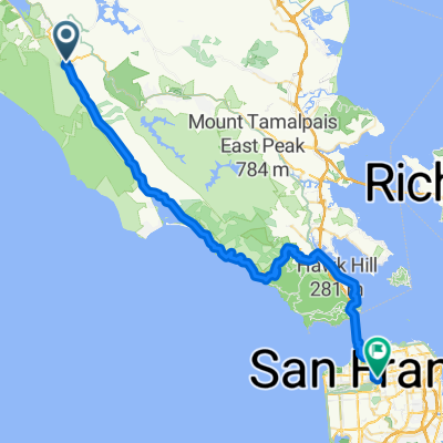
Bolinas Ridge to Hawk Camp
A cycling route starting in Lagunitas-Forest Knolls, California, United States.
Overview
About this route
Park just north of Samuel P. taylor and take Bolinas Ridge into Mt. Tamapaias and over to the Marin headlands ending at Hawk campground
- -:--
- Duration
- 46.7 km
- Distance
- 1,534 m
- Ascent
- 1,342 m
- Descent
- ---
- Avg. speed
- 625 m
- Max. altitude

Route quality
Waytypes & surfaces along the route
Waytypes
Track
28 km
(60 %)
Quiet road
12 km
(26 %)
Surfaces
Paved
12.7 km
(27 %)
Unpaved
13.5 km
(29 %)
Unpaved (undefined)
9.5 km
(20 %)
Paved (undefined)
9.1 km
(19 %)
Continue with Bikemap
Use, edit, or download this cycling route
You would like to ride Bolinas Ridge to Hawk Camp or customize it for your own trip? Here is what you can do with this Bikemap route:
Free features
- Save this route as favorite or in collections
- Copy & plan your own version of this route
- Sync your route with Garmin or Wahoo
Premium features
Free trial for 3 days, or one-time payment. More about Bikemap Premium.
- Navigate this route on iOS & Android
- Export a GPX / KML file of this route
- Create your custom printout (try it for free)
- Download this route for offline navigation
Discover more Premium features.
Get Bikemap PremiumFrom our community
Other popular routes starting in Lagunitas-Forest Knolls
 TT course #2
- Distance
- 10.1 km
- Ascent
- 84 m
- Descent
- 131 m
- Location
- Lagunitas-Forest Knolls, California, United States
 Nicasio to Kehoe and back
- Distance
- 72.1 km
- Ascent
- 478 m
- Descent
- 475 m
- Location
- Lagunitas-Forest Knolls, California, United States
 nicasio - bolinas - panoramic loop
- Distance
- 93.5 km
- Ascent
- 1,489 m
- Descent
- 1,489 m
- Location
- Lagunitas-Forest Knolls, California, United States
 BART: Sam Taylor to Petaluma
- Distance
- 79.3 km
- Ascent
- 2,441 m
- Descent
- 2,505 m
- Location
- Lagunitas-Forest Knolls, California, United States
 Olema to home
- Distance
- 59.3 km
- Ascent
- 856 m
- Descent
- 808 m
- Location
- Lagunitas-Forest Knolls, California, United States
 half moon bay
- Distance
- 94.9 km
- Ascent
- 726 m
- Descent
- 769 m
- Location
- Lagunitas-Forest Knolls, California, United States
 Bolinas Ridge to Hawk Camp
- Distance
- 46.7 km
- Ascent
- 1,534 m
- Descent
- 1,342 m
- Location
- Lagunitas-Forest Knolls, California, United States
 9.94mi Nicasio to Pt Reyes Station 1-way
- Distance
- 16 km
- Ascent
- 90 m
- Descent
- 140 m
- Location
- Lagunitas-Forest Knolls, California, United States
Open it in the app