

LAC D'AUBERT & LAC DE CAP DE LONG
A cycling route starting in Saint-Lary-Soulan, Occitanie, France.
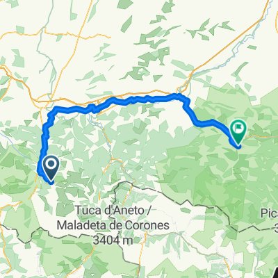
Overview
About this route
Tunnel de Bielsa - Favian - Lac d'Oredón - Lac d'Aumar - Lac d'Aubert - Lac de Cap de Long - Favian.
- -:--
- Duration
- 50 km
- Distance
- 1,688 m
- Ascent
- 2,345 m
- Descent
- ---
- Avg. speed
- 2,205 m
- Max. altitude

Route quality
Waytypes & surfaces along the route
Waytypes
Road
22 km
(44 %)
Quiet road
18 km
(36 %)
Surfaces
Paved
8.5 km
(17 %)
Asphalt
8.5 km
(17 %)
Undefined
41.5 km
(83 %)
Continue with Bikemap
Use, edit, or download this cycling route
You would like to ride LAC D'AUBERT & LAC DE CAP DE LONG or customize it for your own trip? Here is what you can do with this Bikemap route:
Free features
- Save this route as favorite or in collections
- Copy & plan your own version of this route
- Sync your route with Garmin or Wahoo
Premium features
Free trial for 3 days, or one-time payment. More about Bikemap Premium.
- Navigate this route on iOS & Android
- Export a GPX / KML file of this route
- Create your custom printout (try it for free)
- Download this route for offline navigation
Discover more Premium features.
Get Bikemap PremiumFrom our community
Other popular routes starting in Saint-Lary-Soulan
 5 Estarvielle - Llavorsi
- Distance
- 115.7 km
- Ascent
- 2,574 m
- Descent
- 2,724 m
- Location
- Saint-Lary-Soulan, Occitanie, France
 Saint-Lary-Soulan - Saint-Girons
- Distance
- 118.8 km
- Ascent
- 1,552 m
- Descent
- 2,016 m
- Location
- Saint-Lary-Soulan, Occitanie, France
 Pirinei-04-b
- Distance
- 35.4 km
- Ascent
- 1,014 m
- Descent
- 1,115 m
- Location
- Saint-Lary-Soulan, Occitanie, France
 Etapa 1 Pirineos 2013 (144kms)
- Distance
- 144.1 km
- Ascent
- 0 m
- Descent
- 0 m
- Location
- Saint-Lary-Soulan, Occitanie, France
 MTB Pyrenäen Rundfahrt 5 Fabian-Bagners de Bigorre
- Distance
- 80.8 km
- Ascent
- 1,521 m
- Descent
- 1,982 m
- Location
- Saint-Lary-Soulan, Occitanie, France
 Azet-Pla d'Adet
- Distance
- 64.4 km
- Ascent
- 1,747 m
- Descent
- 1,744 m
- Location
- Saint-Lary-Soulan, Occitanie, France
 Sait Lary Soulan-Col d´Azet-Col de Peyresourde-Bagnerés de Luchon-Col du Portillon-Arties
- Distance
- 86 km
- Ascent
- 2,487 m
- Descent
- 2,163 m
- Location
- Saint-Lary-Soulan, Occitanie, France
 F-Pyr-Arreau-112 2400
- Distance
- 110.2 km
- Ascent
- 2,055 m
- Descent
- 2,055 m
- Location
- Saint-Lary-Soulan, Occitanie, France
Open it in the app