

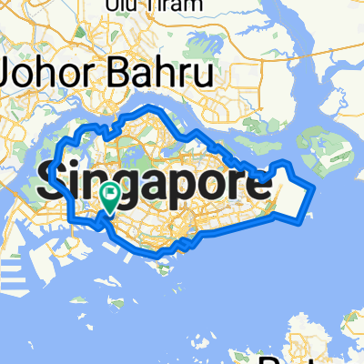
Block 183A Jelebu Rd, to Block 181 Jelebu Rd,
A cycling route starting in Singapore, Central Singapore Community Development Council, Singapore.
Overview
About this route
- 2 h 23 min
- Duration
- 19.6 km
- Distance
- 380 m
- Ascent
- 414 m
- Descent
- 8.2 km/h
- Avg. speed
- 81 m
- Max. altitude

Continue with Bikemap
Use, edit, or download this cycling route
You would like to ride Block 183A Jelebu Rd, to Block 181 Jelebu Rd, or customize it for your own trip? Here is what you can do with this Bikemap route:
Free features
- Save this route as favorite or in collections
- Copy & plan your own version of this route
- Sync your route with Garmin or Wahoo
Premium features
Free trial for 3 days, or one-time payment. More about Bikemap Premium.
- Navigate this route on iOS & Android
- Export a GPX / KML file of this route
- Create your custom printout (try it for free)
- Download this route for offline navigation
Discover more Premium features.
Get Bikemap PremiumFrom our community
Other popular routes starting in Singapore
 Singapore PCN Cycle Loop
- Distance
- 143.4 km
- Ascent
- 556 m
- Descent
- 538 m
- Location
- Singapore, Central Singapore Community Development Council, Singapore
 River Valley Rd, Singapore to Marine Parade, Singapore
- Distance
- 13.6 km
- Ascent
- 109 m
- Descent
- 121 m
- Location
- Singapore, Central Singapore Community Development Council, Singapore
 90-km Eastern Shoreline
- Distance
- 90 km
- Ascent
- 576 m
- Descent
- 578 m
- Location
- Singapore, Central Singapore Community Development Council, Singapore
 Punggol Rd, Singapore to Helix Bridge, Singapore
- Distance
- 17.8 km
- Ascent
- 245 m
- Descent
- 251 m
- Location
- Singapore, Central Singapore Community Development Council, Singapore
 80km - Round (Middle) Island
- Distance
- 78.6 km
- Ascent
- 189 m
- Descent
- 189 m
- Location
- Singapore, Central Singapore Community Development Council, Singapore
 Tampines Hub to Changi Village
- Distance
- 10.2 km
- Ascent
- 87 m
- Descent
- 108 m
- Location
- Singapore, Central Singapore Community Development Council, Singapore
 Half Island SG
- Distance
- 70.9 km
- Ascent
- 479 m
- Descent
- 484 m
- Location
- Singapore, Central Singapore Community Development Council, Singapore
 Bayfront Link, Singapore to Punggol Rd, Singapore
- Distance
- 21.5 km
- Ascent
- 184 m
- Descent
- 208 m
- Location
- Singapore, Central Singapore Community Development Council, Singapore
Open it in the app