

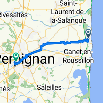
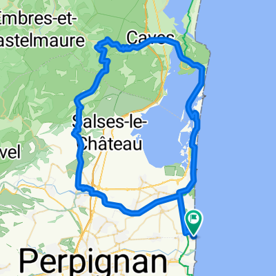
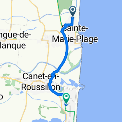
2011 Pyre1
A cycling route starting in Sainte-Marie-Plage, Occitanie, France.
Overview
About this route
Col de Banyuls: in F sehr schlechte Strasse - dort steigen, in E super Strasse! von La Vajol nach F führt eine Piste - gute Qualität - 8% Gefälle. D86 und D13 bieten super Panorama!
- -:--
- Duration
- 139.7 km
- Distance
- 1,634 m
- Ascent
- 1,569 m
- Descent
- ---
- Avg. speed
- ---
- Max. altitude

Continue with Bikemap
Use, edit, or download this cycling route
You would like to ride 2011 Pyre1 or customize it for your own trip? Here is what you can do with this Bikemap route:
Free features
- Save this route as favorite or in collections
- Copy & plan your own version of this route
- Split it into stages to create a multi-day tour
- Sync your route with Garmin or Wahoo
Premium features
Free trial for 3 days, or one-time payment. More about Bikemap Premium.
- Navigate this route on iOS & Android
- Export a GPX / KML file of this route
- Create your custom printout (try it for free)
- Download this route for offline navigation
Discover more Premium features.
Get Bikemap PremiumFrom our community
Other popular routes starting in Sainte-Marie-Plage
 Rondje Sainte marie
- Distance
- 18.6 km
- Ascent
- 4 m
- Descent
- 5 m
- Location
- Sainte-Marie-Plage, Occitanie, France
 Brasilia camping - st. cyprien
- Distance
- 10.7 km
- Ascent
- 6 m
- Descent
- 10 m
- Location
- Sainte-Marie-Plage, Occitanie, France
 Sainte Marie-Plage2Perpignan Gare
- Distance
- 17.7 km
- Ascent
- 35 m
- Descent
- 0 m
- Location
- Sainte-Marie-Plage, Occitanie, France
 De Les Illes 1443, Sainte-Marie-la-Mer a Chemin du maritime, Narbonne
- Distance
- 61.3 km
- Ascent
- 102 m
- Descent
- 98 m
- Location
- Sainte-Marie-Plage, Occitanie, France
 tour du lac
- Distance
- 82.1 km
- Ascent
- 427 m
- Descent
- 429 m
- Location
- Sainte-Marie-Plage, Occitanie, France
 Avenue des Dunes, Sainte-Marie-la-Mer à Rue des Dahlias, Canet-en-Roussillon
- Distance
- 7.6 km
- Ascent
- 8 m
- Descent
- 6 m
- Location
- Sainte-Marie-Plage, Occitanie, France
 Canet 1
- Distance
- 68.2 km
- Ascent
- 303 m
- Descent
- 302 m
- Location
- Sainte-Marie-Plage, Occitanie, France
 2011 Pyre1
- Distance
- 139.7 km
- Ascent
- 1,634 m
- Descent
- 1,569 m
- Location
- Sainte-Marie-Plage, Occitanie, France
Open it in the app