

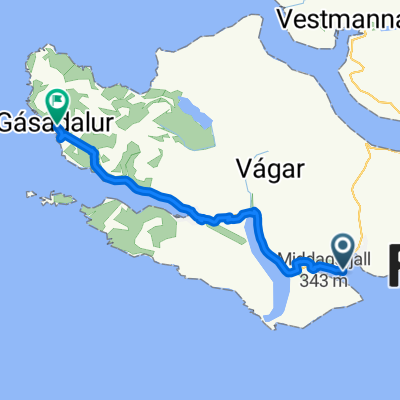
Áarlið, to Á Giljatrøðni,
A cycling route starting in Miðvágur, Vágar region, Faroe Islands.
Overview
About this route
- 59 min
- Duration
- 12.6 km
- Distance
- 337 m
- Ascent
- 339 m
- Descent
- 12.9 km/h
- Avg. speed
- 170 m
- Max. altitude

Route quality
Waytypes & surfaces along the route
Waytypes
Quiet road
3.7 km
(29 %)
Access road
3.7 km
(29 %)
Surfaces
Paved
2.6 km
(21 %)
Unpaved
0.6 km
(5 %)
Paved (undefined)
2.1 km
(17 %)
Gravel
0.6 km
(5 %)
Continue with Bikemap
Use, edit, or download this cycling route
You would like to ride Áarlið, to Á Giljatrøðni, or customize it for your own trip? Here is what you can do with this Bikemap route:
Free features
- Save this route as favorite or in collections
- Copy & plan your own version of this route
- Sync your route with Garmin or Wahoo
Premium features
Free trial for 3 days, or one-time payment. More about Bikemap Premium.
- Navigate this route on iOS & Android
- Export a GPX / KML file of this route
- Create your custom printout (try it for free)
- Download this route for offline navigation
Discover more Premium features.
Get Bikemap PremiumFrom our community
Other popular routes starting in Miðvágur
 Áarlið, to Heiðagøta,
- Distance
- 3.4 km
- Ascent
- 49 m
- Descent
- 55 m
- Location
- Miðvágur, Vágar region, Faroe Islands
 Á Giljatrøðni, to Á Giljatrøðni,
- Distance
- 3.1 km
- Ascent
- 96 m
- Descent
- 98 m
- Location
- Miðvágur, Vágar region, Faroe Islands
 Á Giljatrøðni, to Á Giljatrøðni,
- Distance
- 6.5 km
- Ascent
- 220 m
- Descent
- 218 m
- Location
- Miðvágur, Vágar region, Faroe Islands
 Áarlið, to Á Giljatrøðni,
- Distance
- 12.6 km
- Ascent
- 337 m
- Descent
- 339 m
- Location
- Miðvágur, Vágar region, Faroe Islands
 Giljavegur, to Á Giljatrøðni,
- Distance
- 12.2 km
- Ascent
- 542 m
- Descent
- 541 m
- Location
- Miðvágur, Vágar region, Faroe Islands
 Miðvágur - Vestmanna
- Distance
- 78.9 km
- Ascent
- 0 m
- Descent
- 0 m
- Location
- Miðvágur, Vágar region, Faroe Islands
 Faroe islands
- Distance
- 221.5 km
- Ascent
- 0 m
- Descent
- 0 m
- Location
- Miðvágur, Vágar region, Faroe Islands
 á Hillingatanga nach Langagerði
- Distance
- 20.9 km
- Ascent
- 527 m
- Descent
- 471 m
- Location
- Miðvágur, Vágar region, Faroe Islands
Open it in the app