

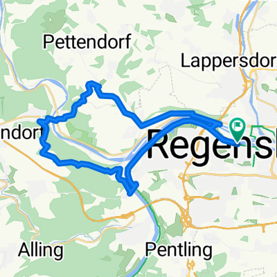
Regensburg - Eilsbrunn - Sinzing CLONED FROM ROUTE 93621
A cycling route starting in Regensburg, Bavaria, Germany.
Overview
About this route
Die Strecke ist recht hügelig. Auf der Marienhöhe geht sie entlang eines im Wald versteckten Mountainbike-Trails. Den kann man allerdings bei Bedarf umfahren. In Eilsbrunn bietet sich die Möglichkeit einen Biergartenstop einzulegen. Entlang der Laaber ist die Strecke eher flach und abfallend (flussabwärts). Nach Alling gehts nochmal steil bergauf. Bei der Abfahrt nach Sinzing fährt man mitten durch den Übungsgolfplatz. Hier auf die abschlagenden Golfer achten. Wer das nicht will kann etwas weiter südlich runterfahren. Teilweise wäre ein Fully angebracht gewesen. Allerdings kann mans auch mit einem Hardtail fahren.
- -:--
- Duration
- 30.5 km
- Distance
- 322 m
- Ascent
- 321 m
- Descent
- ---
- Avg. speed
- ---
- Avg. speed
Route quality
Waytypes & surfaces along the route
Waytypes
Path
10.2 km
(34 %)
Quiet road
8 km
(26 %)
Surfaces
Paved
15.6 km
(51 %)
Unpaved
11.8 km
(39 %)
Asphalt
13.8 km
(45 %)
Gravel
8.4 km
(27 %)
Continue with Bikemap
Use, edit, or download this cycling route
You would like to ride Regensburg - Eilsbrunn - Sinzing CLONED FROM ROUTE 93621 or customize it for your own trip? Here is what you can do with this Bikemap route:
Free features
- Save this route as favorite or in collections
- Copy & plan your own version of this route
- Sync your route with Garmin or Wahoo
Premium features
Free trial for 3 days, or one-time payment. More about Bikemap Premium.
- Navigate this route on iOS & Android
- Export a GPX / KML file of this route
- Create your custom printout (try it for free)
- Download this route for offline navigation
Discover more Premium features.
Get Bikemap PremiumFrom our community
Other popular routes starting in Regensburg
 Mittlere Tour Regensburg - Donau und zurück
- Distance
- 20.7 km
- Ascent
- 222 m
- Descent
- 182 m
- Location
- Regensburg, Bavaria, Germany
 Fünf-Flüsse-Radtour mit Start in Regensburg
- Distance
- 308.4 km
- Ascent
- 2,967 m
- Descent
- 3,006 m
- Location
- Regensburg, Bavaria, Germany
 Rgbg-Marienhöhe-Etterzhausen-Adlersberg-Rgbg
- Distance
- 25.2 km
- Ascent
- 274 m
- Descent
- 274 m
- Location
- Regensburg, Bavaria, Germany
 Ausgedehnte Feierabendtour
- Distance
- 62.9 km
- Ascent
- 392 m
- Descent
- 392 m
- Location
- Regensburg, Bavaria, Germany
 Donau - Laber Tour über Lindach
- Distance
- 44.6 km
- Ascent
- 435 m
- Descent
- 433 m
- Location
- Regensburg, Bavaria, Germany
 Trailhunter
- Distance
- 55.7 km
- Ascent
- 746 m
- Descent
- 729 m
- Location
- Regensburg, Bavaria, Germany
 Fuenf-Flüsse-Radweg
- Distance
- 308.2 km
- Ascent
- 343 m
- Descent
- 341 m
- Location
- Regensburg, Bavaria, Germany
 Arber Radmarathon MtB kurz
- Distance
- 55 km
- Ascent
- 704 m
- Descent
- 702 m
- Location
- Regensburg, Bavaria, Germany
Open it in the app