

del real
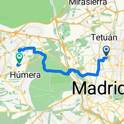
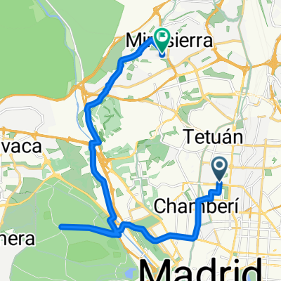
A cycling route starting in Chamberí, Madrid, Spain.
Overview
About this route
- -:--
- Duration
- 49.2 km
- Distance
- 564 m
- Ascent
- 323 m
- Descent
- ---
- Avg. speed
- 942 m
- Max. altitude
Route quality
Waytypes & surfaces along the route
Waytypes
Cycleway
30.5 km
(62 %)
Road
2 km
(4 %)
Surfaces
Paved
37.4 km
(76 %)
Unpaved
0.5 km
(1 %)
Asphalt
35.4 km
(72 %)
Concrete
2 km
(4 %)
Continue with Bikemap
Use, edit, or download this cycling route
You would like to ride del real or customize it for your own trip? Here is what you can do with this Bikemap route:
Free features
- Save this route as favorite or in collections
- Copy & plan your own version of this route
- Sync your route with Garmin or Wahoo
Premium features
Free trial for 3 days, or one-time payment. More about Bikemap Premium.
- Navigate this route on iOS & Android
- Export a GPX / KML file of this route
- Create your custom printout (try it for free)
- Download this route for offline navigation
Discover more Premium features.
Get Bikemap PremiumFrom our community
Other popular routes starting in Chamberí
 Madrid by feet
- Distance
- 13.3 km
- Ascent
- 120 m
- Descent
- 204 m
- Location
- Chamberí, Madrid, Spain
 Gran Ruta Circular-NW
- Distance
- 129.8 km
- Ascent
- 796 m
- Descent
- 794 m
- Location
- Chamberí, Madrid, Spain
 Madrid chamberi a Tres Cantos
- Distance
- 22 km
- Ascent
- 123 m
- Descent
- 72 m
- Location
- Chamberí, Madrid, Spain
 Madrid - El escorial
- Distance
- 76 km
- Ascent
- 647 m
- Descent
- 306 m
- Location
- Chamberí, Madrid, Spain
 Madrid-Pozuelo
- Distance
- 14.8 km
- Ascent
- 1,277 m
- Descent
- 1,279 m
- Location
- Chamberí, Madrid, Spain
 del real
- Distance
- 49.2 km
- Ascent
- 564 m
- Descent
- 323 m
- Location
- Chamberí, Madrid, Spain
 A Ventisquero de la Condesa
- Distance
- 19.6 km
- Ascent
- 711 m
- Descent
- 718 m
- Location
- Chamberí, Madrid, Spain
 Anillo verde norte
- Distance
- 41.3 km
- Ascent
- 366 m
- Descent
- 360 m
- Location
- Chamberí, Madrid, Spain
Open it in the app