

Fichtelgebirgstour 3 Hohenberg-Weissenstadt CLONED FROM ROUTE 514481
A cycling route starting in Hazlov, Karlovarský kraj, Czechia.
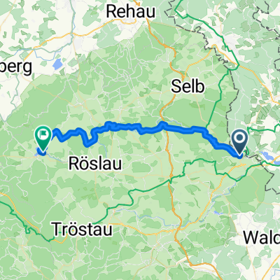
Overview
About this route
Zurück an der Eger bis hinter Markleuthen, dann etwas abseits der Eger bis Weissenstadt am See...Wetter wieder durchwachsen,und wieder kein Regentropfen abgekriegt
- -:--
- Duration
- 35.8 km
- Distance
- 405 m
- Ascent
- 294 m
- Descent
- ---
- Avg. speed
- ---
- Max. altitude

Route quality
Waytypes & surfaces along the route
Waytypes
Quiet road
16.1 km
(45 %)
Track
11.2 km
(31 %)
Surfaces
Paved
6.3 km
(18 %)
Unpaved
11.4 km
(32 %)
Gravel
8.1 km
(23 %)
Asphalt
4.9 km
(14 %)
Continue with Bikemap
Use, edit, or download this cycling route
You would like to ride Fichtelgebirgstour 3 Hohenberg-Weissenstadt CLONED FROM ROUTE 514481 or customize it for your own trip? Here is what you can do with this Bikemap route:
Free features
- Save this route as favorite or in collections
- Copy & plan your own version of this route
- Sync your route with Garmin or Wahoo
Premium features
Free trial for 3 days, or one-time payment. More about Bikemap Premium.
- Navigate this route on iOS & Android
- Export a GPX / KML file of this route
- Create your custom printout (try it for free)
- Download this route for offline navigation
Discover more Premium features.
Get Bikemap PremiumFrom our community
Other popular routes starting in Hazlov
 VKZč 2019 - č.1- 55/670
- Distance
- 54.5 km
- Ascent
- 573 m
- Descent
- 350 m
- Location
- Hazlov, Karlovarský kraj, Czechia
 2010 Fichtelgebirgstour 2 Hohenbergrunde
- Distance
- 17.4 km
- Ascent
- 345 m
- Descent
- 348 m
- Location
- Hazlov, Karlovarský kraj, Czechia
 2010 Fichtelgebirgstour 3 Hohenberg-Weissenstadt
- Distance
- 35.7 km
- Ascent
- 394 m
- Descent
- 283 m
- Location
- Hazlov, Karlovarský kraj, Czechia
 Mainradweg Mainz bis Hohenberg an der Eger
- Distance
- 585.8 km
- Ascent
- 287 m
- Descent
- 726 m
- Location
- Hazlov, Karlovarský kraj, Czechia
 09 Hazlov Cheb
- Distance
- 60.9 km
- Ascent
- 522 m
- Descent
- 595 m
- Location
- Hazlov, Karlovarský kraj, Czechia
 VKZč 2019 - 1 - č 47/620
- Distance
- 48.1 km
- Ascent
- 653 m
- Descent
- 427 m
- Location
- Hazlov, Karlovarský kraj, Czechia
 Fichtelgebirgstour 3 Hohenberg-Weissenstadt CLONED FROM ROUTE 514481
- Distance
- 35.8 km
- Ascent
- 405 m
- Descent
- 294 m
- Location
- Hazlov, Karlovarský kraj, Czechia
 Grenze Nord - Prag
- Distance
- 183.4 km
- Ascent
- 1,071 m
- Descent
- 1,324 m
- Location
- Hazlov, Karlovarský kraj, Czechia
Open it in the app