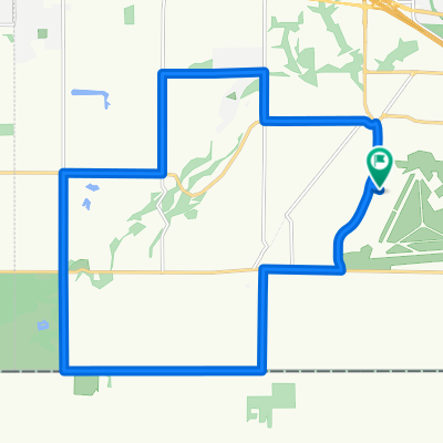
Overview
About this route
Work to home safetly with the least amount of left hand turns
Takes you through the raspberry roundabout however
- -:--
- Duration
- 10.2 km
- Distance
- 81 m
- Ascent
- 67 m
- Descent
- ---
- Avg. speed
- 82 m
- Max. altitude
Part of
Going Home
1 stage
Route quality
Waytypes & surfaces along the route
Waytypes
Quiet road
3.2 km
(31 %)
Road
2.7 km
(26 %)
Surfaces
Paved
9.5 km
(93 %)
Asphalt
9.4 km
(92 %)
Concrete
0.1 km
(1 %)
Undefined
0.7 km
(7 %)
Route highlights
Points of interest along the route
Point of interest after 0 km
Work
Point of interest after 10.2 km
Home
Continue with Bikemap
Use, edit, or download this cycling route
You would like to ride Work to Home (Safe) or customize it for your own trip? Here is what you can do with this Bikemap route:
Free features
- Save this route as favorite or in collections
- Copy & plan your own version of this route
- Sync your route with Garmin or Wahoo
Premium features
Free trial for 3 days, or one-time payment. More about Bikemap Premium.
- Navigate this route on iOS & Android
- Export a GPX / KML file of this route
- Create your custom printout (try it for free)
- Download this route for offline navigation
Discover more Premium features.
Get Bikemap PremiumFrom our community
Other popular routes starting in Aldergrove
- 2644 275A St, Langley to 2644 275A St, Langley
- Distance
- 52.2 km
- Ascent
- 507 m
- Descent
- 512 m
- Location
- Aldergrove, British Columbia, Canada
- Discovery Trail Abbotsford
- Distance
- 15.8 km
- Ascent
- 228 m
- Descent
- 223 m
- Location
- Aldergrove, British Columbia, Canada
- TCT West meets East
- Distance
- 23.1 km
- Ascent
- 318 m
- Descent
- 313 m
- Location
- Aldergrove, British Columbia, Canada
- Work to Home (Safe)
- Distance
- 10.2 km
- Ascent
- 81 m
- Descent
- 67 m
- Location
- Aldergrove, British Columbia, Canada
- Aldergrove Border Crossing to South Whatcom Lake
- Distance
- 55.6 km
- Ascent
- 430 m
- Descent
- 386 m
- Location
- Aldergrove, British Columbia, Canada
- 2013 - Colombie-Britannique - Final-1/3
- Distance
- 702.9 km
- Ascent
- 1,810 m
- Descent
- 1,409 m
- Location
- Aldergrove, British Columbia, Canada
- Aldergrove to Chilliwack
- Distance
- 49.6 km
- Ascent
- 203 m
- Descent
- 296 m
- Location
- Aldergrove, British Columbia, Canada
- Abbotsford 80
- Distance
- 82.2 km
- Ascent
- 265 m
- Descent
- 264 m
- Location
- Aldergrove, British Columbia, Canada
Open it in the app